Take-off site requirements.
Provide a clean, stable, level, non-metallic surface in an open area for take-off.
Suitable for take-off: special folding drone landing pads, folding tables, the drone case, sheets of plywood, wood or plastic at least 40x40 cm, boxes of a suitable size. Not suitable for take-off: a car hood or roof (they contain metal, which may disturb the compass), ground covered with sand or fine gravel (sand or small stones may get into the gimbal or drone motors), snow or grass.
Compass calibration.
Calibrate the compass before the first take-off at each new site according to the drone manual. Calibrate away from metal objects (cars, buildings, bridges, all-terrain vehicles, etc.) and sources of electromagnetic radiation (power lines, magnets, generators, etc.). The operator must not carry magnets during compass calibration.
Camera image settings.
Before the aerial survey it is strongly recommended to set up the camera image using the following parameter ranges:
- Exposure: from -1.0 to +1.0;
- Shooting mode: aperture priority (A) or shutter priority (S);
- Shutter speed: from 1/2000 s to tmax s, where tmax is the maximum exposure time;
- Aperture: from F3.5 to F7.1;
- ISO: from 100 to 800, set automatically.
| Sunny | Partly cloudy | Overcast | |
| Shutter speed | 1/2000 – 1/1250 | 1/1250 – 1/800 | 1/800 – 1/500 |
| Aperture | F7.1 – F5.6 | F5.6 – F4 | F4 – F3.5 |
| ISO | 100 – 200 | 200 – 400 | 400 – 800 |
Examples of camera image settings for different weather conditions.
The maximum allowable exposure time tmax depends on the drone's flight speed and altitude. The exact value for a given altitude and speed can be taken from the table.
Flight speed 5 m/s 6 m/s 7 m/s 8 m/s 9 m/s 10 m/s 11 m/s 12 m/s GSD Altitude (m) 1.0 36 1/500 1/640 1/800 1/800 1/1000 1/1000 1/1250 1/1600 1.5 55 1/400 1/400 1/500 1/640 1/640 1/800 1/800 1/800 2.0 73 1/320 1/320 1/400 1/400 1/500 1/640 1/640 1/640 2.5 91 1/200 1/240 1/320 1/320 1/400 1/500 1/500 1/500 3.0 111 1/200 1/200 1/240 1/320 1/320 1/400 1/400 1/400 3.5 128 1/160 1/200 1/200 1/240 1/320 1/320 1/320 1/400 4.0 146 1/160 1/160 1/200 1/200 1/240 1/320 1/320 1/320 4.5 165 1/120 1/160 1/160 1/200 1/200 1/240 1/320 1/320 5.0 183 1/100 1/120 1/160 1/160 1/200 1/200 1/240 1/240
Shooting modes.
Different shooting modes make it easy to control the image parameters while staying within the recommended values. The DJI Mavic 3 Enterprise has 4 photo modes for aerial surveys:
Auto – not recommended; A – aperture priority; S – shutter priority; M – Manual – not recommended.
In Auto mode all shooting parameters (ISO, aperture, shutter speed) are selected automatically. However, during aerial photography in motion they are not always optimal, which causes motion blur of the ground in the photos. This significantly reduces the accuracy of the resulting materials.
In aperture priority mode (A), a constant aperture and a target exposure value are set. The shutter speed and ISO change and adjust automatically.
In shutter priority mode (S), a constant shutter speed and a target exposure value are set. The aperture and ISO change and adjust automatically. This mode is recommended for aerial photography in low light, when the shutter speed is set to the maximum up to tmax.
In Manual mode all image parameters are set manually. This mode suits experienced users in constant weather conditions.
Focus setup.
To improve the accuracy of the final materials, it is recommended to use the same focus for all photos. To make this value correct, do the following before the route flight:
| Take off with the M3E to the working altitude (the altitude planned for the aerial survey). Go to the camera view and lower the camera with the left dial of the remote controller. Then select the AFC focus mode in the upper right and half-press the «Photo» button on the remote controller. Switch the focus mode from AFC to MF | Switch the focus mode to AFC and focus on the ground from the working altitude Then switch the focus mode to MF 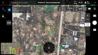 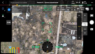 |
It is best to set up the camera image and focus when the M3E is in the air at the working altitude of the route. To do this, make a preliminary take-off before starting the route, or pause the route with the «Pause» button when the M3E reaches the working altitude.