Knowledge base
Blog
Services
  • Surveying equipment development
    • Drone and VTOL camera development
    • LiDAR development for your brand
  • Surveying services
    • Bathymetric survey service
    • Laser scanning and photogrammetry data processing
    • Laser scanning service
    • Photogrammetry service
  • Surveyor training
    • Comprehensive training in flight and data processing
Company
  • Staff
  • News
  • Reviews
  • Vacancy
  • Licenses
  • Documents
  • Partners
Information
  • Requisites
Brands
Contacts
    +41 21 588 02 11
    +41 21 588 02 11 09:00-18:00 whatsapp.svg
    Sales [email protected] email.png
    Support [email protected] email.png
    Telegram Channel @topodronesa tg.svg
    Telegram Chat @topodronesagroup tg.svg
    Telegram Bot @topodronecombot tg.svg
    Facebook @topodronesa ycz1c9257s6gh7g315r8q6tob3bnddba.png
    Youtube @topodronesa youtube.png
    LinkedIn @topodrone 9ratq3v3eavnhupo1akvxp0sbx4vopj5.png
    X @topodrone twitter.png
    Instagram @topodrone tpxkj71axu6dxt423lwj5idzwcej1njx.png
    Email
    [email protected] - Sales
    [email protected] - Support
    The address
    TOPODRONE SA, Rue de la Gare 13, 1820 Montreux, Switzerland
    Working hours
    10:00-18:00
    TOPODRONE
    SPH Engineering
    3Dsurvey
    Velodyne
    DJI
    GreenValley International
    Honeywell
    Fixar
    Blue Marble Geographics
    Sony
    Agisoft
    EMLID
    Pix4D
    Autel Robotics
    SHAREUAV
    • LiDAR
      LiDAR
      • Aerial Survey LiDAR
      • SLAM Survey LiDAR
      • LiDAR Accessories
    • Bathymetry
      Bathymetry
    • Photogrammetry
      Photogrammetry
      • Mapping Drones
      • Drone Mapping Cameras
      • VTOL Mapping Cameras
    • PPK Upgrade Kits
      PPK Upgrade Kits
      • PPK for Drones
      • PPK for any UAV
    • Spectrography
      Spectrography
      • Thermal
      • Multispectral
    • UAV
      UAV
      • DJI
      • Autel Robotics
      • FIXAR
      • Innotech drone
    • Payload
      Payload
      • Aerial Survey LiDAR
      • Bathymetric Scanner
      • Photogrammetric Cameras
      • Thermal Cameras
      • Multispectral Cameras
      • Beacon
    • Software
      Software
      • TOPODRONE
      • UgCS
      • Agisoft
      • 3Dsurvey
      • LiDAR360
      • DJI
      • PIX4D
    • GNSS Equipment
      GNSS Equipment
      • EMLID
      • DJI
    TOPODRONE – LiDAR & UAV Survey
    Log in
    0 Comparison
    0 Favorites
    0 Cart
    TOPODRONE – LiDAR & UAV Survey
    Log in
    0 Comparison
    0 Favorites
    0 Cart
    TOPODRONE – LiDAR & UAV Survey
    Telephones
    +41 21 588 02 11 09:00-18:00 whatsapp.svg
    Sales [email protected] email.png
    Support [email protected] email.png
    Telegram Channel @topodronesa tg.svg
    Telegram Chat @topodronesagroup tg.svg
    Telegram Bot @topodronecombot tg.svg
    Facebook @topodronesa ycz1c9257s6gh7g315r8q6tob3bnddba.png
    Youtube @topodronesa youtube.png
    LinkedIn @topodrone 9ratq3v3eavnhupo1akvxp0sbx4vopj5.png
    X @topodrone twitter.png
    Instagram @topodrone tpxkj71axu6dxt423lwj5idzwcej1njx.png
    Email
    [email protected] - Sales
    [email protected] - Support
    The address
    TOPODRONE SA, Rue de la Gare 13, 1820 Montreux, Switzerland
    Working hours
    10:00-18:00
    0
    0
    0
    • Cabinet
    • 0 Compare
    • 0 Favorite
    • 0 Cart
    • Brands
    • Sales
    • Services
      • Services
      • Surveying equipment development
        • Surveying equipment development
        • Drone and VTOL camera development
        • LiDAR development for your brand
      • Surveying services
        • Surveying services
        • Bathymetric survey service
        • Laser scanning and photogrammetry data processing
        • Laser scanning service
        • Photogrammetry service
      • Surveyor training
        • Surveyor training
        • Comprehensive training in flight and data processing
    • Company
      • Company
      • Staff
      • News
      • Reviews
      • Vacancy
      • Licenses
      • Documents
      • Partners
    • Blog
    • Information
      • Information
      • Requisites
    • Contacts
    +41 21 588 02 11 09:00-18:00
    • Telephones
    • +41 21 588 02 11 09:00-18:00
      whatsapp.svg
    • Sales [email protected]
      email.png
    • Support [email protected]
      email.png
    • Telegram Channel @topodronesa
      tg.svg
    • Telegram Chat @topodronesagroup
      tg.svg
    • Telegram Bot @topodronecombot
      tg.svg
    • Facebook @topodronesa
      ycz1c9257s6gh7g315r8q6tob3bnddba.png
    • Youtube @topodronesa
      youtube.png
    • LinkedIn @topodrone
      9ratq3v3eavnhupo1akvxp0sbx4vopj5.png
    • X @topodrone
      twitter.png
    • Instagram @topodrone
      tpxkj71axu6dxt423lwj5idzwcej1njx.png
    • [email protected] - Sales
      [email protected] - Support
    • TOPODRONE SA, Rue de la Gare 13, 1820 Montreux, Switzerland
    • 10:00-18:00
    Main
    Products
    Software
    TOPODRONE
    TOPODRONE Post Processing Pro to Expert, Upgrade
    TOPODRONE Post Processing Pro to Expert, Upgrade

    TOPODRONE Post Processing Pro to Expert, Upgrade

    5
    Art. TDCH8107
    $4 500
    Available
    Specifications
    Warranty : 12 months
    $4 500
    Available
    • Description
    • Reviews
    • Specifications

    TOPODRONE Post Processing Expert is the most comprehensive version of TOPODRONE software for professional geodetic data post-processing. This product is intended for users who already work with the Pro version and wish to upgrade to the full Expert package.

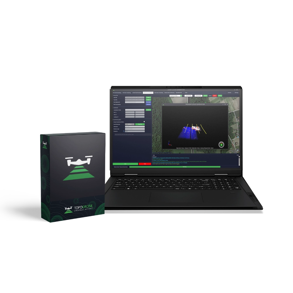
    The upgrade adds integrated processing of GNSS receiver and IMU (Inertial Measurement Unit) data, as well as support for the LiDAR Post Processing module for advanced laser scanning data workflows.

    The software incorporates cutting-edge algorithms for trajectory computation, point cloud generation, refinement of photo centre coordinates, PPP and RTK processing, and IMU data integration for maximum accuracy. Despite its advanced functionality, the TOPODRONE Post Processing Expert interface remains intuitive and versatile — making it an ideal tool for specialists in geodesy, mine surveying, aerial mapping, 3D cartography, and engineering investigations.

    Advantages of upgrading from Pro to Expert

    • Includes all functionality from the Pro version.
    • Integrated processing of GNSS receiver and IMU data.
    • Full LiDAR data workflow support: from trajectory computation to point cloud generation.
    • Server-based LiDAR processing with no load on the user’s workstation.
    • Access to new tools and features unavailable in the Pro version.
    • High-precision PPP, RTK, Static and PPK algorithms.
    • Support for user-defined coordinate systems and geoid models.
    • Perpetual licence with 1 year of technical support and updates from the moment of upgrade.

    More detailed information about TOPODRONE Post Processing can be found in the user guide in the TOPODRONE Knowledge Base.

    Modules added when upgrading to Expert

    Module Description
    LiDAR Post Processing Integrated GNSS and IMU data processing with scanner trajectory computation on TOPODRONE server infrastructure.
    LiDAR Cloud Generation Point cloud generation and calibration of roll, pitch and heading angles (extended functionality compared to Pro).
    Integrated GNSS + IMU Processing Data fusion for precise trajectory reconstruction and enhanced georeferencing.

    The remaining Pro modules remain available.

    Updates and support

    The licence is perpetual. One year of updates and technical support is included from the date of upgrade. After the update period ends, the software remains fully functional but without access to new versions or support until the next renewal.

    Upgrade package contents

    • TOPODRONE Post Processing Expert licence (upgrade from Pro, perpetual).
    • 1 year of technical support and updates from the moment of activation.
    • User guide and documentation.

    Loading...
    5
    Common
    Warranty
    12 months