Knowledge base
Blog
Services
  • Surveying equipment development
    • Drone and VTOL camera development
    • LiDAR development for your brand
  • Surveying services
    • Bathymetric survey service
    • Laser scanning and photogrammetry data processing
    • Laser scanning service
    • Photogrammetry service
  • Surveyor training
    • Comprehensive training in flight and data processing
Company
  • Staff
  • News
  • Reviews
  • Vacancy
  • Licenses
  • Documents
  • Partners
Information
  • Requisites
Brands
Contacts
    +41 21 588 02 11
    +41 21 588 02 11 09:00-18:00 whatsapp.svg
    Sales [email protected] email.png
    Support [email protected] email.png
    Telegram Channel @topodronesa tg.svg
    Telegram Chat @topodronesagroup tg.svg
    Telegram Bot @topodronecombot tg.svg
    Facebook @topodronesa ycz1c9257s6gh7g315r8q6tob3bnddba.png
    Youtube @topodronesa youtube.png
    LinkedIn @topodrone 9ratq3v3eavnhupo1akvxp0sbx4vopj5.png
    X @topodrone twitter.png
    Instagram @topodrone tpxkj71axu6dxt423lwj5idzwcej1njx.png
    Email
    [email protected] - Sales
    [email protected] - Support
    The address
    TOPODRONE SA, Rue de la Gare 13, 1820 Montreux, Switzerland
    Working hours
    10:00-18:00
    TOPODRONE
    SPH Engineering
    3Dsurvey
    Velodyne
    DJI
    GreenValley International
    Honeywell
    Fixar
    Blue Marble Geographics
    Sony
    Agisoft
    EMLID
    Pix4D
    Autel Robotics
    SHAREUAV
    • LiDAR
      LiDAR
      • Aerial Survey LiDAR
      • SLAM Survey LiDAR
      • LiDAR Accessories
    • Bathymetry
      Bathymetry
    • Photogrammetry
      Photogrammetry
      • Mapping Drones
      • Drone Mapping Cameras
      • VTOL Mapping Cameras
    • PPK Upgrade Kits
      PPK Upgrade Kits
      • PPK for Drones
      • PPK for any UAV
    • Spectrography
      Spectrography
      • Thermal
      • Multispectral
    • UAV
      UAV
      • DJI
      • Autel Robotics
      • FIXAR
      • Innotech drone
    • Payload
      Payload
      • Aerial Survey LiDAR
      • Bathymetric Scanner
      • Photogrammetric Cameras
      • Thermal Cameras
      • Multispectral Cameras
      • Beacon
    • Software
      Software
      • TOPODRONE
      • UgCS
      • Agisoft
      • 3Dsurvey
      • LiDAR360
      • DJI
      • PIX4D
    • GNSS Equipment
      GNSS Equipment
      • EMLID
      • DJI
    TOPODRONE – LiDAR & UAV Survey
    Log in
    0 Comparison
    0 Favorites
    0 Cart
    TOPODRONE – LiDAR & UAV Survey
    Log in
    0 Comparison
    0 Favorites
    0 Cart
    TOPODRONE – LiDAR & UAV Survey
    Telephones
    +41 21 588 02 11 09:00-18:00 whatsapp.svg
    Sales [email protected] email.png
    Support [email protected] email.png
    Telegram Channel @topodronesa tg.svg
    Telegram Chat @topodronesagroup tg.svg
    Telegram Bot @topodronecombot tg.svg
    Facebook @topodronesa ycz1c9257s6gh7g315r8q6tob3bnddba.png
    Youtube @topodronesa youtube.png
    LinkedIn @topodrone 9ratq3v3eavnhupo1akvxp0sbx4vopj5.png
    X @topodrone twitter.png
    Instagram @topodrone tpxkj71axu6dxt423lwj5idzwcej1njx.png
    Email
    [email protected] - Sales
    [email protected] - Support
    The address
    TOPODRONE SA, Rue de la Gare 13, 1820 Montreux, Switzerland
    Working hours
    10:00-18:00
    0
    0
    0
    • Cabinet
    • 0 Compare
    • 0 Favorite
    • 0 Cart
    • Brands
    • Sales
    • Services
      • Services
      • Surveying equipment development
        • Surveying equipment development
        • Drone and VTOL camera development
        • LiDAR development for your brand
      • Surveying services
        • Surveying services
        • Bathymetric survey service
        • Laser scanning and photogrammetry data processing
        • Laser scanning service
        • Photogrammetry service
      • Surveyor training
        • Surveyor training
        • Comprehensive training in flight and data processing
    • Company
      • Company
      • Staff
      • News
      • Reviews
      • Vacancy
      • Licenses
      • Documents
      • Partners
    • Blog
    • Information
      • Information
      • Requisites
    • Contacts
    +41 21 588 02 11 09:00-18:00
    • Telephones
    • +41 21 588 02 11 09:00-18:00
      whatsapp.svg
    • Sales [email protected]
      email.png
    • Support [email protected]
      email.png
    • Telegram Channel @topodronesa
      tg.svg
    • Telegram Chat @topodronesagroup
      tg.svg
    • Telegram Bot @topodronecombot
      tg.svg
    • Facebook @topodronesa
      ycz1c9257s6gh7g315r8q6tob3bnddba.png
    • Youtube @topodronesa
      youtube.png
    • LinkedIn @topodrone
      9ratq3v3eavnhupo1akvxp0sbx4vopj5.png
    • X @topodrone
      twitter.png
    • Instagram @topodrone
      tpxkj71axu6dxt423lwj5idzwcej1njx.png
    • [email protected] - Sales
      [email protected] - Support
    • TOPODRONE SA, Rue de la Gare 13, 1820 Montreux, Switzerland
    • 10:00-18:00
    Main
    Products
    Software
    PIX4D
    PIX4Dmapper
    PIX4Dmapper, Single Device, 1 Year S&U After Expiry
    PIX4Dmapper, Single Device, 1 Year S&U After Expiry

    PIX4Dmapper, Single Device, 1 Year S&U After Expiry

    5
    Art. TDCH89109
    $1 312.48
    Available
    Specifications
    Warranty : 12 months
    $1 312.48
    Available
    • Description
    • Reviews
    • Specifications

    PIX4Dmapper – Reliable Professional Photogrammetry Software

    PIX4Dmapper is reliable professional software for photogrammetric processing of data captured by drones, ground-based cameras and specialised sensors. It transforms aerial and terrestrial images into highly accurate digital maps, 3D models and engineering deliverables. The software supports RGB, thermal, multispectral and panoramic (360°) imagery, fisheye lenses and camera rigs.

    The software is designed for surveyors, cartographers, engineers, mining surveyors and inspection specialists. With correct data acquisition it provides sub-centimetre accuracy and gives full control over the processing workflow.

    Key Benefits of PIX4Dmapper

    High-Precision Processing

    • Sub-centimetre accuracy when using GCPs.

    Typical accuracy:

    Axis Typical accuracy
    X, Y 1–2 pixels GSD
    Z 1–3 pixels GSD

    Full Project Control

    • Definition of a Region of Interest (ROI).
    • Flexible processing modes: automatic or fully manual.
    • Advanced configuration of calibration, dense point cloud, mesh and orthomosaic algorithms.
    • Full editing of point clouds, DSMs, textured 3D models and orthomosaics.

    Flexible Workflow

    • Local processing on a desktop or workstation.
    • Or combined use with PIX4Dcloud for cloud computing, storage and sharing.

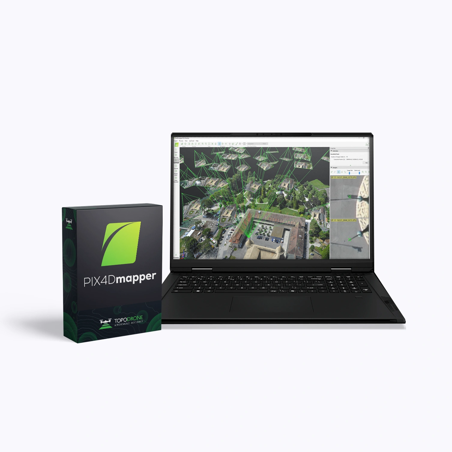
    rayCloud™ – Unique Visual Verification Environment

    A tool that links every point of the 3D reconstruction to the original images. It allows you to:

    • Check and control accuracy.
    • Adjust GCPs, Checkpoints and MTPs.
    • Improve calibration and overall project geometry.
    • Quickly detect and correct processing errors.

    Measurement and Analysis Tools

    • Distance, area and volume measurements.
    • Configurable base height.
    • Object inspection tools using images and 3D models.

    Machine Learning

    • Automatic point cloud classification (ground, buildings, vegetation, roads and more).
    • Support for processing complex surfaces, including:
      • DSM smoothing,
      • plane creation,
      • filling gaps and correcting artefacts.

    High-Quality Reporting

    A detailed Quality Report includes:

    • Camera calibration check.
    • Assessment of tie-point quality.
    • Project geometry overview.
    • Accuracy of control points.
    • Preview of key outputs.

    Core Functionality

    Capture – Data Collection

    • Support for any drones and cameras: RGB, multispectral, thermal, fisheye, 360°, camera rigs and video frames.
    • Image formats: .jpg / .tif.

    Digitize – Digital Modelling

    Automatic photogrammetric processing with generation of:

    • dense point cloud,
    • orthomosaic,
    • DSM,
    • textured 3D model (mesh).

    Control – Quality Control

    • rayCloud™ for visual verification.
    • Full workflow for working with GCPs, Checkpoints and MTPs.
    • Detailed Quality Report.

    Measure & Inspect – Measurement and Inspection

    • Measurement of distances, areas and volumes.
    • Object inspection in 2D and 3D.
    • Linking measurements back to the original images.

    Collaborate & Share – Collaboration

    • Export of data to standardised formats.
    • Secure project sharing, including integration with PIX4Dcloud.
    Loading...
    5
    Common
    Warranty
    12 months