Knowledge base
Blog
Services
  • Surveying equipment development
    • Drone and VTOL camera development
    • LiDAR development for your brand
  • Surveying services
    • Bathymetric survey service
    • Laser scanning and photogrammetry data processing
    • Laser scanning service
    • Photogrammetry service
  • Surveyor training
    • Comprehensive training in flight and data processing
Company
  • Staff
  • News
  • Reviews
  • Vacancy
  • Licenses
  • Documents
  • Partners
Information
  • Requisites
Brands
Contacts
    +41 21 588 02 11
    +41 21 588 02 11 09:00-18:00 whatsapp.svg
    Sales [email protected] email.png
    Support [email protected] email.png
    Telegram Channel @topodronesa tg.svg
    Telegram Chat @topodronesagroup tg.svg
    Telegram Bot @topodronecombot tg.svg
    Facebook @topodronesa ycz1c9257s6gh7g315r8q6tob3bnddba.png
    Youtube @topodronesa youtube.png
    LinkedIn @topodrone 9ratq3v3eavnhupo1akvxp0sbx4vopj5.png
    X @topodrone twitter.png
    Instagram @topodrone tpxkj71axu6dxt423lwj5idzwcej1njx.png
    Email
    [email protected] - Sales
    [email protected] - Support
    The address
    TOPODRONE SA, Rue de la Gare 13, 1820 Montreux, Switzerland
    Working hours
    10:00-18:00
    TOPODRONE
    SPH Engineering
    3Dsurvey
    Velodyne
    DJI
    GreenValley International
    Honeywell
    Fixar
    Blue Marble Geographics
    Sony
    Agisoft
    EMLID
    Pix4D
    Autel Robotics
    SHAREUAV
    • LiDAR
      LiDAR
      • Aerial Survey LiDAR
      • SLAM Survey LiDAR
      • LiDAR Accessories
    • Bathymetry
      Bathymetry
    • Photogrammetry
      Photogrammetry
      • Mapping Drones
      • Drone Mapping Cameras
      • VTOL Mapping Cameras
    • PPK Upgrade Kits
      PPK Upgrade Kits
      • PPK for Drones
      • PPK for any UAV
    • Spectrography
      Spectrography
      • Thermal
      • Multispectral
    • UAV
      UAV
      • DJI
      • Autel Robotics
      • FIXAR
      • Innotech drone
    • Payload
      Payload
      • Aerial Survey LiDAR
      • Bathymetric Scanner
      • Photogrammetric Cameras
      • Thermal Cameras
      • Multispectral Cameras
      • Beacon
    • Software
      Software
      • TOPODRONE
      • UgCS
      • Agisoft
      • 3Dsurvey
      • LiDAR360
      • DJI
      • PIX4D
    • GNSS Equipment
      GNSS Equipment
      • EMLID
      • DJI
    TOPODRONE – LiDAR & UAV Survey
    Log in
    0 Comparison
    0 Favorites
    0 Cart
    TOPODRONE – LiDAR & UAV Survey
    Log in
    0 Comparison
    0 Favorites
    0 Cart
    TOPODRONE – LiDAR & UAV Survey
    Telephones
    +41 21 588 02 11 09:00-18:00 whatsapp.svg
    Sales [email protected] email.png
    Support [email protected] email.png
    Telegram Channel @topodronesa tg.svg
    Telegram Chat @topodronesagroup tg.svg
    Telegram Bot @topodronecombot tg.svg
    Facebook @topodronesa ycz1c9257s6gh7g315r8q6tob3bnddba.png
    Youtube @topodronesa youtube.png
    LinkedIn @topodrone 9ratq3v3eavnhupo1akvxp0sbx4vopj5.png
    X @topodrone twitter.png
    Instagram @topodrone tpxkj71axu6dxt423lwj5idzwcej1njx.png
    Email
    [email protected] - Sales
    [email protected] - Support
    The address
    TOPODRONE SA, Rue de la Gare 13, 1820 Montreux, Switzerland
    Working hours
    10:00-18:00
    0
    0
    0
    • Cabinet
    • 0 Compare
    • 0 Favorite
    • 0 Cart
    • Brands
    • Sales
    • Services
      • Services
      • Surveying equipment development
        • Surveying equipment development
        • Drone and VTOL camera development
        • LiDAR development for your brand
      • Surveying services
        • Surveying services
        • Bathymetric survey service
        • Laser scanning and photogrammetry data processing
        • Laser scanning service
        • Photogrammetry service
      • Surveyor training
        • Surveyor training
        • Comprehensive training in flight and data processing
    • Company
      • Company
      • Staff
      • News
      • Reviews
      • Vacancy
      • Licenses
      • Documents
      • Partners
    • Blog
    • Information
      • Information
      • Requisites
    • Contacts
    +41 21 588 02 11 09:00-18:00
    • Telephones
    • +41 21 588 02 11 09:00-18:00
      whatsapp.svg
    • Sales [email protected]
      email.png
    • Support [email protected]
      email.png
    • Telegram Channel @topodronesa
      tg.svg
    • Telegram Chat @topodronesagroup
      tg.svg
    • Telegram Bot @topodronecombot
      tg.svg
    • Facebook @topodronesa
      ycz1c9257s6gh7g315r8q6tob3bnddba.png
    • Youtube @topodronesa
      youtube.png
    • LinkedIn @topodrone
      9ratq3v3eavnhupo1akvxp0sbx4vopj5.png
    • X @topodrone
      twitter.png
    • Instagram @topodrone
      tpxkj71axu6dxt423lwj5idzwcej1njx.png
    • [email protected] - Sales
      [email protected] - Support
    • TOPODRONE SA, Rue de la Gare 13, 1820 Montreux, Switzerland
    • 10:00-18:00
    Main
    Products
    Software
    LiDAR360
    LiDAR360 Powerline, Next Version Upgrade
    LiDAR360 Powerline, Next Version Upgrade

    LiDAR360 Powerline, Next Version Upgrade

    5
    Art. TDCH8614
    $260
    Available
    Specifications
    Warranty : 12 months
    $260
    Available
    • Description
    • Reviews
    • Specifications

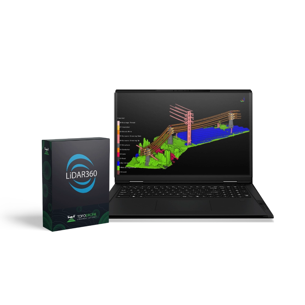
    LiDAR360 Powerline is a specialised module for the analysis and monitoring of power transmission lines using LiDAR data. Developed for energy companies, engineers, and infrastructure specialists, it provides a comprehensive solution for assessing the condition of powerlines, analysing surrounding environments, and improving operational safety.

    Upgrade Licence (Upgrade to the Next Major Version)

    A one-time upgrade of an existing licence to the next major version of the module.

    Terms:

    • Applicable to previous versions (e.g. V8 → V9).
    • Upgrading is sequential — version skipping is not allowed (e.g. V6 → V7 → V8).
    • Major upgrade (transition to the next primary version).
    • Minor updates (patches and builds containing fixes and incremental improvements) — free for 1 year.
    • Technical support is extended for the entire duration of the upgraded licence.

    Main Features:

    • Detection and classification of powerline assets: automatic identification of poles, conductors, insulators, and other infrastructure components.
    • Vegetation analysis: detection and assessment of areas where trees or shrubs pose potential risks to powerlines, with the capability to calculate minimum safe clearance distances.
    • Safety clearance monitoring: automated calculation of distances between conductors, structures, and surrounding objects to prevent faults and short circuits.
    • Condition monitoring: comparison of datasets from different time periods to identify deformations, sagging, or damage to powerline components.
    • 3D visualisation: creation of accurate three-dimensional models of network sections for inspection planning, reconstruction, and maintenance activities.

    Who LiDAR360 Powerline Is For:

    LiDAR360 Powerline is ideal for power utilities, O&M contractors, design engineers, and infrastructure monitoring professionals. The module helps enhance safety, reduce operational risks, and optimise the management of energy network assets.

    Conclusion:

    LiDAR360 Powerline is a reliable solution for automating powerline analysis and preventing critical incidents. With advanced LiDAR processing algorithms and accurate modelling, it provides a new level of control over the condition of your infrastructure.

    Ensure the safety and stability of your energy facilities with LiDAR360 Powerline.
    Upgrade your licence today!

    Loading...
    5
    Common
    Warranty
    12 months