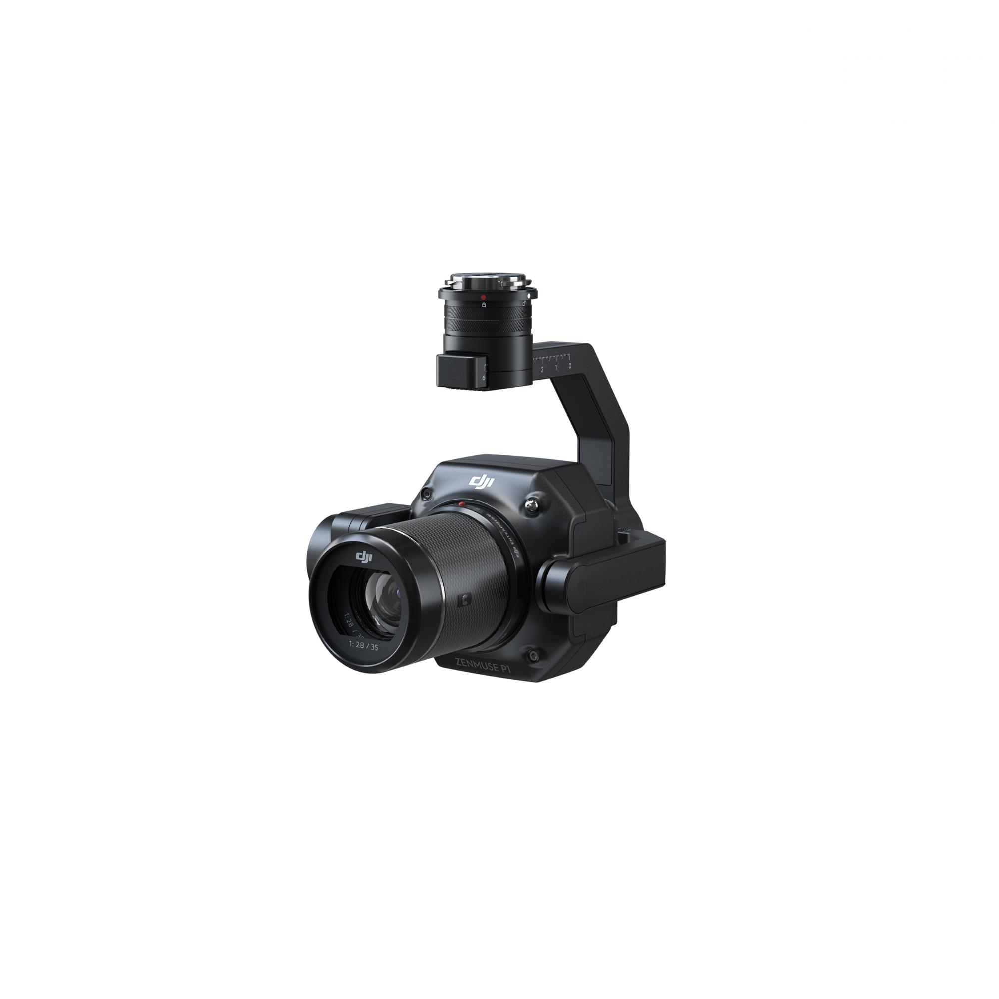
Knowledge base
Blog
Services
  • Surveying equipment development
    • Drone and VTOL camera development
    • LiDAR development for your brand
  • Surveying services
    • Bathymetric survey service
    • Laser scanning and photogrammetry data processing
    • Laser scanning service
    • Photogrammetry service
  • Surveyor training
    • Comprehensive training in flight and data processing
Company
  • Staff
  • News
  • Reviews
  • Vacancy
  • Licenses
  • Documents
  • Partners
Information
  • Requisites
Brands
Contacts
    +41 21 588 02 11
    +41 21 588 02 11 09:00-18:00 whatsapp.svg
    Sales [email protected] email.png
    Support [email protected] email.png
    Telegram Channel @topodronesa tg.svg
    Telegram Chat @topodronesagroup tg.svg
    Telegram Bot @topodronecombot tg.svg
    Facebook @topodronesa ycz1c9257s6gh7g315r8q6tob3bnddba.png
    Youtube @topodronesa youtube.png
    LinkedIn @topodrone 9ratq3v3eavnhupo1akvxp0sbx4vopj5.png
    X @topodrone twitter.png
    Instagram @topodrone tpxkj71axu6dxt423lwj5idzwcej1njx.png
    Email
    [email protected] - Sales
    [email protected] - Support
    The address
    TOPODRONE SA, Rue de la Gare 13, 1820 Montreux, Switzerland
    Working hours
    10:00-18:00
    TOPODRONE
    SPH Engineering
    3Dsurvey
    Velodyne
    DJI
    GreenValley International
    Honeywell
    Fixar
    Blue Marble Geographics
    Sony
    Agisoft
    EMLID
    Pix4D
    Autel Robotics
    SHAREUAV
    • LiDAR
      LiDAR
      • Aerial Survey LiDAR
      • SLAM Survey LiDAR
      • LiDAR Accessories
    • Bathymetry
      Bathymetry
    • Photogrammetry
      Photogrammetry
      • Mapping Drones
      • Drone Mapping Cameras
      • VTOL Mapping Cameras
    • PPK Upgrade Kits
      PPK Upgrade Kits
      • PPK for Drones
      • PPK for any UAV
    • Spectrography
      Spectrography
      • Thermal
      • Multispectral
    • UAV
      UAV
      • DJI
      • Autel Robotics
      • FIXAR
      • Innotech drone
    • Payload
      Payload
      • Aerial Survey LiDAR
      • Bathymetric Scanner
      • Photogrammetric Cameras
      • Thermal Cameras
      • Multispectral Cameras
      • Beacon
    • Software
      Software
      • TOPODRONE
      • UgCS
      • Agisoft
      • 3Dsurvey
      • LiDAR360
      • DJI
      • PIX4D
    • GNSS Equipment
      GNSS Equipment
      • EMLID
      • DJI
    TOPODRONE – LiDAR & UAV Survey
    Log in
    0 Comparison
    0 Favorites
    0 Cart
    TOPODRONE – LiDAR & UAV Survey
    Log in
    0 Comparison
    0 Favorites
    0 Cart
    TOPODRONE – LiDAR & UAV Survey
    Telephones
    +41 21 588 02 11 09:00-18:00 whatsapp.svg
    Sales [email protected] email.png
    Support [email protected] email.png
    Telegram Channel @topodronesa tg.svg
    Telegram Chat @topodronesagroup tg.svg
    Telegram Bot @topodronecombot tg.svg
    Facebook @topodronesa ycz1c9257s6gh7g315r8q6tob3bnddba.png
    Youtube @topodronesa youtube.png
    LinkedIn @topodrone 9ratq3v3eavnhupo1akvxp0sbx4vopj5.png
    X @topodrone twitter.png
    Instagram @topodrone tpxkj71axu6dxt423lwj5idzwcej1njx.png
    Email
    [email protected] - Sales
    [email protected] - Support
    The address
    TOPODRONE SA, Rue de la Gare 13, 1820 Montreux, Switzerland
    Working hours
    10:00-18:00
    0
    0
    0
    • Cabinet
    • 0 Compare
    • 0 Favorite
    • 0 Cart
    • Brands
    • Sales
    • Services
      • Services
      • Surveying equipment development
        • Surveying equipment development
        • Drone and VTOL camera development
        • LiDAR development for your brand
      • Surveying services
        • Surveying services
        • Bathymetric survey service
        • Laser scanning and photogrammetry data processing
        • Laser scanning service
        • Photogrammetry service
      • Surveyor training
        • Surveyor training
        • Comprehensive training in flight and data processing
    • Company
      • Company
      • Staff
      • News
      • Reviews
      • Vacancy
      • Licenses
      • Documents
      • Partners
    • Blog
    • Information
      • Information
      • Requisites
    • Contacts
    +41 21 588 02 11 09:00-18:00
    • Telephones
    • +41 21 588 02 11 09:00-18:00
      whatsapp.svg
    • Sales [email protected]
      email.png
    • Support [email protected]
      email.png
    • Telegram Channel @topodronesa
      tg.svg
    • Telegram Chat @topodronesagroup
      tg.svg
    • Telegram Bot @topodronecombot
      tg.svg
    • Facebook @topodronesa
      ycz1c9257s6gh7g315r8q6tob3bnddba.png
    • Youtube @topodronesa
      youtube.png
    • LinkedIn @topodrone
      9ratq3v3eavnhupo1akvxp0sbx4vopj5.png
    • X @topodrone
      twitter.png
    • Instagram @topodrone
      tpxkj71axu6dxt423lwj5idzwcej1njx.png
    • [email protected] - Sales
      [email protected] - Support
    • TOPODRONE SA, Rue de la Gare 13, 1820 Montreux, Switzerland
    • 10:00-18:00
    Main
    Products
    Payload
    Photogrammetric Cameras
    DJI Zenmuse P1
    DJI Zenmuse P1
    DJI Zenmuse P1
    DJI Zenmuse P1
    DJI Zenmuse P1
    DJI Zenmuse P1
    DJI Zenmuse P1

    DJI Zenmuse P1

    5
    Art. TDCH7301
    $4 700
    Available
    Specifications
    Country of origin : China
    Warranty : 12 months
    $4 700
    Available
    DJI
    All items of DJI
    All products of the category
    • Description
    • Reviews
    • Specifications

    DJI Zenmuse P1 is a high-precision photogrammetric camera featuring a 45 MP full-frame sensor mounted on a 3-axis stabilized gimbal. Designed for professional aerial missions, it delivers maximum efficiency and exceptional detail, even across large survey areas. The TimeSync 2.0 system ensures perfect synchronization between the camera, flight controller, and RTK module, enabling centimeter-level accuracy.

    Functionality:

    • 2D and 3D imaging: generation of topographic maps, point clouds, and detailed models.
    • Smart Oblique Capture: simplified acquisition of complex oblique imagery for 3D modeling.
    • High sensitivity and low noise: ensures high-quality images even in low-light conditions.
    • Interchangeable lenses: flexible selection of focal lengths for different survey missions.
    • Maximum flight efficiency: covers large areas in a single flight with rapid, high-detail image capture.

    Advantages:

    • High data accuracy: delivers results with horizontal accuracy up to 3 cm and vertical accuracy up to 5 cm without ground control points.
    • Operational efficiency: covers up to 3 km² in a single flight, with an image capture interval as short as 0.7 s.
    • Application flexibility: suitable for topography, surveying, cadastre, natural resource monitoring, geological studies, and incident analysis.
    • Reliability and quality: the mechanical shutter and stabilized gimbal minimize distortions and motion blur.
    • DJI ecosystem integration: TimeSync 2.0 ensures perfect synchronization of all modules for accurate georeferencing.

    Applications:

    • Topographic mapping: fast creation of detailed digital terrain models.
    • Surveying and construction: high-precision point clouds and 3D models for project management.
    • Cadastre: precise 3D models of objects with centimeter-level accuracy.
    • Natural resource monitoring: measurement and control of forests, water bodies, and land areas.
    • Geological research: safe data collection in hard-to-reach locations.
    • Incident analysis: detailed imaging for quick decision-making.

    Loading...
    5
    Common
    Country of origin
    China
    Warranty
    12 months