| To determine the Beacon's coordinates (degrees, WGS84), the following conditions must be met: 1) The Radio must be tuned to the Beacon's frequency. By default the Radio is already tuned to the required frequency, in most cases 433.075 MHz. 2) The Beacon and the Radio are within radio range. In open terrain without obstacles and interference, the range is up to 2 km. In rough terrain with obstacles (forest, relief), the range may be up to 1 km. 3) Both devices are switched on. After switching on, the Beacon receives the GNSS signal for at least 5 minutes. To determine the Beacon's coordinates, on the switched-on Radio press and hold the «PTT» (black button on the left side) and «A/B» (blue button on the front) buttons for 3 seconds. The Radio will then send a request signal to the Beacon. The Beacon will reply with a voice message dictating the digits in the following order: | 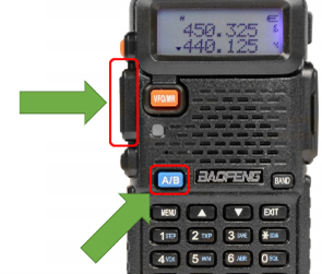 |
| Fig. 11. PTT and A/B buttons on the Radio |
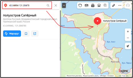 | ZZ (pause) XX (pause) XXXXXX (pause) YY (pause) YYYYYYY (repeat), ZZ – signal quality in %, XX.XXXXXX – latitude, YY.YYYYYY – longitude Example: 84 43 04994 131 88478. This means 84% signal quality, latitude 43.04994, longitude 131.88478. Enter the latitude and longitude (43.04994 131.88478) into the search bar of any map service, for example Google Maps, and press «Search». The map service will show the Beacon's location on the map. |
| Fig. 12. Finding the Beacon's position by coordinates in a map service |