






Knowledge base
Blog
Services
  • Aerial Photography
    • UAV Monitoring & Inspections
    • UAV Photogrammetry
  • Laser Scanning
    • Aerial Laser Scanning
    • Quarry Surveying
    • Topographical Surveying
  • Training
    • UAV Pilot Course: Photogrammetry & ALS
Company
  • Staff
  • News
  • Reviews
  • Vacancy
  • Licenses
  • Documents
  • Partners
Information
  • Requisites
Brands
Contacts
    +41 21 588 02 11
    +41 21 588 02 11 09:00-18:00 whatsapp.svg
    Sales [email protected] email.png
    Support [email protected] email.png
    Telegram Channel @topodronesa tg.svg
    Telegram Chat @topodronesagroup tg.svg
    Telegram Bot @topodronecombot tg.svg
    Facebook @topodronesa ycz1c9257s6gh7g315r8q6tob3bnddba.png
    Youtube @topodronesa youtube.png
    LinkedIn @topodrone 9ratq3v3eavnhupo1akvxp0sbx4vopj5.png
    X @topodrone twitter.png
    Instagram @topodrone tpxkj71axu6dxt423lwj5idzwcej1njx.png
    Email
    [email protected] - Sales
    [email protected] - Support
    The address
    TOPODRONE SA, Rue de la Gare 13, 1820 Montreux, Switzerland
    Working hours
    10:00-18:00
    TOPODRONE
    SPH Engineering
    3Dsurvey
    Velodyne
    DJI
    GreenValley International
    Honeywell
    Fixar
    Blue Marble Geographics
    Sony
    Agisoft
    EMLID
    Pix4D
    Autel Robotics
    SHAREUAV
    • LiDAR
      LiDAR
      • Aerial Survey LiDAR
      • SLAM Survey LiDAR
      • LiDAR Accessories
    • Bathymetry
      Bathymetry
    • Photogrammetry
      Photogrammetry
      • Mapping Drones
      • Drone Mapping Cameras
      • VTOL Mapping Cameras
    • PPK Upgrade Kits
      PPK Upgrade Kits
      • PPK for Drones
      • PPK for any UAV
    • Spectrography
      Spectrography
      • Thermal
      • Multispectral
    • UAV
      UAV
      • DJI
      • Autel Robotics
      • FIXAR
      • Innotech drone
    • Payload
      Payload
      • Aerial Survey LiDAR
      • Bathymetric Scanner
      • Photogrammetric Cameras
      • Thermal Cameras
      • Multispectral Cameras
      • Beacon
    • Software
      Software
      • TOPODRONE
      • UgCS
      • Agisoft
      • 3Dsurvey
      • LiDAR360
      • DJI
      • PIX4D
    • GNSS Equipment
      GNSS Equipment
      • EMLID
      • DJI
    TOPODRONE – LiDAR & UAV Survey
    Log in
    0 Comparison
    0 Favorites
    0 Cart
    TOPODRONE – LiDAR & UAV Survey
    Log in
    0 Comparison
    0 Favorites
    0 Cart
    TOPODRONE – LiDAR & UAV Survey
    Telephones
    +41 21 588 02 11 09:00-18:00 whatsapp.svg
    Sales [email protected] email.png
    Support [email protected] email.png
    Telegram Channel @topodronesa tg.svg
    Telegram Chat @topodronesagroup tg.svg
    Telegram Bot @topodronecombot tg.svg
    Facebook @topodronesa ycz1c9257s6gh7g315r8q6tob3bnddba.png
    Youtube @topodronesa youtube.png
    LinkedIn @topodrone 9ratq3v3eavnhupo1akvxp0sbx4vopj5.png
    X @topodrone twitter.png
    Instagram @topodrone tpxkj71axu6dxt423lwj5idzwcej1njx.png
    Email
    [email protected] - Sales
    [email protected] - Support
    The address
    TOPODRONE SA, Rue de la Gare 13, 1820 Montreux, Switzerland
    Working hours
    10:00-18:00
    0
    0
    0
    • Cabinet
    • 0 Compare
    • 0 Favorite
    • 0 Cart
    • Brands
    • Sales
    • Services
      • Services
      • Aerial Photography
        • Aerial Photography
        • UAV Monitoring & Inspections
        • UAV Photogrammetry
      • Laser Scanning
        • Laser Scanning
        • Aerial Laser Scanning
        • Quarry Surveying
        • Topographical Surveying
      • Training
        • Training
        • UAV Pilot Course: Photogrammetry & ALS
    • Company
      • Company
      • Staff
      • News
      • Reviews
      • Vacancy
      • Licenses
      • Documents
      • Partners
    • Blog
    • Information
      • Information
      • Requisites
    • Contacts
    +41 21 588 02 11 09:00-18:00
    • Telephones
    • +41 21 588 02 11 09:00-18:00
      whatsapp.svg
    • Sales [email protected]
      email.png
    • Support [email protected]
      email.png
    • Telegram Channel @topodronesa
      tg.svg
    • Telegram Chat @topodronesagroup
      tg.svg
    • Telegram Bot @topodronecombot
      tg.svg
    • Facebook @topodronesa
      ycz1c9257s6gh7g315r8q6tob3bnddba.png
    • Youtube @topodronesa
      youtube.png
    • LinkedIn @topodrone
      9ratq3v3eavnhupo1akvxp0sbx4vopj5.png
    • X @topodrone
      twitter.png
    • Instagram @topodrone
      tpxkj71axu6dxt423lwj5idzwcej1njx.png
    • [email protected] - Sales
      [email protected] - Support
    • TOPODRONE SA, Rue de la Gare 13, 1820 Montreux, Switzerland
    • 10:00-18:00
    Main
    Blog
    TOPODRONE AUTEL EVO II PRO PPK - A WORTHY ADDITION TO THE RANKS OF PROFESSIONAL SURVEYING DRONES

    TOPODRONE AUTEL EVO II PRO PPK - A WORTHY ADDITION TO THE RANKS OF PROFESSIONAL SURVEYING DRONES

    TOPODRONE AUTEL EVO II PRO PPK - A WORTHY ADDITION TO THE RANKS OF PROFESSIONAL SURVEYING DRONES
    11 May 2022

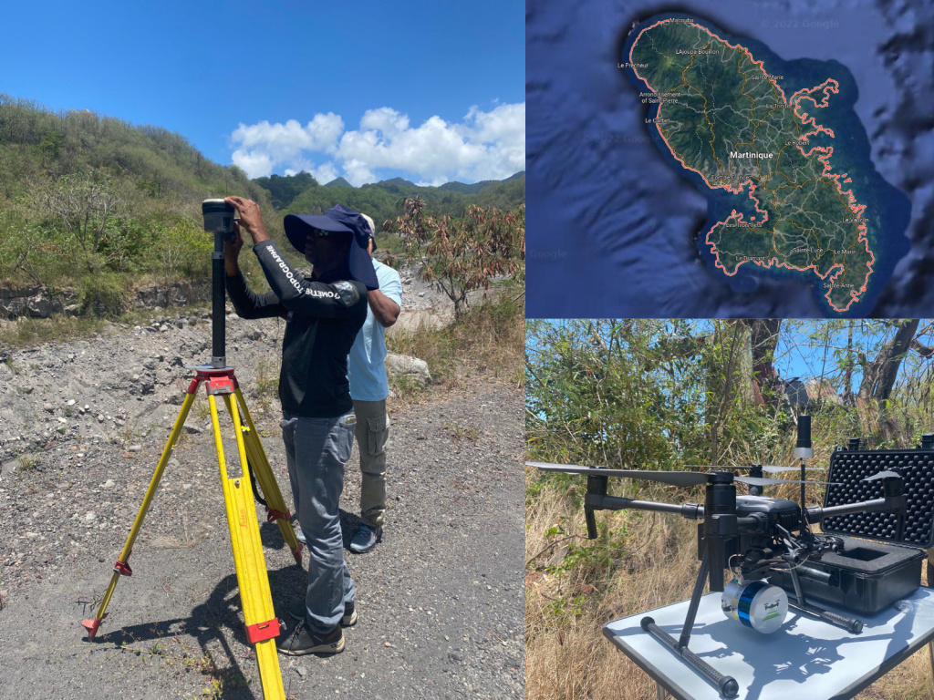
    A few weeks ago, one of our LiDAR users from Martinique asked us to activate PPK on his AUTEL EVO II PRO drone in order to avoid using a large number of GCPs. As you know Martinique island located in the Caribbean Sea has a rugged mountainous terrain due to the recent volcanic activity and is overgrown with dense tropical forests. So the use of conventional survey techniques with UAVs and using control points practically nullifies the advantages of drones. Since every project requires literally scrambling through jungle thickets clambering over steep slopes.
    01.jpg

    Figure 1. TOPODRONE LIDAR HI-RES and DJI Matrice 200 at Martinique island.

    In order to help our client, TOPODRONE team has developed a unique PPK module, which can be installed on AUTEL EVO II PRO and converts the images captured by a regular consumer drone into highly accurate 3D models and orthophoto, eliminating the dependence on GCPs.

    To be honest, we were impressed with the quality of the images taken with the TOPODRONE AUTEL EVO II PRO PPK. We performed a series of tests to compare data from DJI MAVIC 2 PRO, AUTEL EVO II PRO and recently announced by DJI MAVIC 3. Below are samples taken from a height of 70 meters, where you can see the advantage of AUTEL for clarity, color reproduction, lower noise level and even, as we think, higher resolution of the camera, which, in our opinion, will increase the accuracy of photogrammetric processing and detail of 3D models created as well as orthophoto maps.

    02.png

    Figure 2. Comparison of aerial images from DJI MAVIC 2 PRO, DJI MAVIC 3 and AUTEL EVO II PRO drones

    03.png

    Figure 3. Comparison of aerial images from DJI MAVIC 2 PRO, DJI MAVIC 3 and AUTEL EVO II PRO drones

    In order to confirm these we carried out an aerial survey of a 10 ha test site with the AUTEL EVO II PRO survey drone with additional PPK TOPODRONE equipment on board from a height of 70 m in double grid mode, where more than 20 control points were measured and photogrammetric processing was performed with Agisoft Metashape and 3Dsurvey software.

    During the fieldwork stage we noticed that the drone has quite a long flight time of around 40 minutes, which is one more significant advantage of AUTEL over DJI MAVIC 2 PRO and even DJI MAVIC 3, as well as convenient mission planning application, with possibility of manual camera focusing on a certain range and continuing aerial survey mission in case the signal from the remote control is lost.

    It is important to note that the TOPODRONE GNSS receiver is synchronized with the AUTEL camera and provides coordinates of photo locations with centimeter accuracy, both in plan and elevation.

    As a base station you can use any available GNSS receiver within 20km of the survey area, while PPK processing provides a more accurate calculation of the drone's trajectory and image co-ordinates compared to RTK technology.

    For data post-processing and image geo-tagging, we used TOPODRONE Post Processing software, in which in the first stage we calculated in static mode the coordinates of a base station installed in close proximity to the work area from another permanent base located at a distance of 20 km, and then we performed the calculation of highly accurate coordinates of the images.

    04.png

    Figure 4. Updated TOPODRONE Post Processing GUI showing base station location and image coordinates on the map.

    In the next step, we imported photos with high-precision coordinates stored in EXIF tags into 3D Survey software, performed aerial triangulation and corrected distortions associated with the rolling shutter without the use of ground control points.

    05.png

    Figure 5. Location of images and GCPs in 3Dsurvey software.

    06.png

    Figure 6. Results of image block adjustment in 3Dsurvey software.

    Then, evenly distributed across the entire work area control points were loaded and we carried out the accuracy assessment shown in the table.

    07.png

    Figure 7. Report for estimating the accuracy of the model compared to the reference points.

    As you can see, errors on most control points do not exceed 1-3 cm in x,y and up to 5 cm in height, which puts this surveying device on a level with more expensive drones, while still offering great opportunities, thanks to its compact design, high photo quality and flight times of up to 40 minutes.

    Next, we performed point cloud generation, which was highly detailed, low-noise and highly accurate.

    08.png

    Figure 8. A highly detailed point cloud

    09.png

    Figure 9. A highly detailed point cloud

    10.png

    Figure 10. A highly detailed point cloud

    11.png

    Figure 11. A highly detailed point cloud

    For a complete analysis, the control points and 3D terrain model were combined in 3D space, which showed us a real level of data coincidence.

    In the final part of this publication, we would like to let you draw your own conclusions about the new TOPODRONE AUTEL EVO II PPK survey drone, based on the above information about the resolution and quality of the images, the geometric accuracy of 1-3 cm and the high detail of the resulting 3D model.

    12.png

    Figure 12. Alignment of the 3D position of the reference marker and the point cloud.

    13.png

    Figure 13. Alignment of the 3D position of the reference marker and the point cloud.

    14.png

    Figure 14. Alignment of the 3D position of the reference marker and the point cloud.


    • Comments
    Loading comments ...
    Back to the list
    Subscribe to the newsletter of our news and stocks
    Subscribe to
    Connect with us
    +41 21 588 02 11
    +41 21 588 02 11 09:00-18:00 whatsapp.svg
    Sales [email protected] email.png
    Support [email protected] email.png
    Telegram Channel @topodronesa tg.svg
    Telegram Chat @topodronesagroup tg.svg
    Telegram Bot @topodronecombot tg.svg
    Facebook @topodronesa ycz1c9257s6gh7g315r8q6tob3bnddba.png
    Youtube @topodronesa youtube.png
    LinkedIn @topodrone 9ratq3v3eavnhupo1akvxp0sbx4vopj5.png
    X @topodrone twitter.png
    Instagram @topodrone tpxkj71axu6dxt423lwj5idzwcej1njx.png
    Email
    [email protected] - Sales
    [email protected] - Support
    The address
    TOPODRONE SA, Rue de la Gare 13, 1820 Montreux, Switzerland
    Working hours
    10:00-18:00
    [email protected] - Sales
    [email protected] - Support
    TOPODRONE SA, Rue de la Gare 13, 1820 Montreux, Switzerland
    Products
    Sales
    Brands
    Services
    Applications
    Company
    Staff
    News
    Reviews
    Vacancy
    Licenses
    Documents
    Partners
    Information
    Requisites
    Help
    Payment
    Delivery
    Warranty
    FAQ
    © 2026 TOPODRONE SA
    Privacy Policy
    Main page Product 0 Comparison Contacts Blog Applications