






Knowledge base
Blog
Services
  • Aerial Photography
    • UAV Monitoring & Inspections
    • UAV Photogrammetry
  • Laser Scanning
    • Aerial Laser Scanning
    • Quarry Surveying
    • Topographical Surveying
  • Training
    • UAV Pilot Course: Photogrammetry & ALS
Company
  • Staff
  • News
  • Reviews
  • Vacancy
  • Licenses
  • Documents
  • Partners
Information
  • Requisites
Brands
Contacts
    +41 21 588 02 11
    +41 21 588 02 11 09:00-18:00 whatsapp.svg
    Sales [email protected] email.png
    Support [email protected] email.png
    Telegram Channel @topodronesa tg.svg
    Telegram Chat @topodronesagroup tg.svg
    Telegram Bot @topodronecombot tg.svg
    Facebook @topodronesa ycz1c9257s6gh7g315r8q6tob3bnddba.png
    Youtube @topodronesa youtube.png
    LinkedIn @topodrone 9ratq3v3eavnhupo1akvxp0sbx4vopj5.png
    X @topodrone twitter.png
    Instagram @topodrone tpxkj71axu6dxt423lwj5idzwcej1njx.png
    Email
    [email protected] - Sales
    [email protected] - Support
    The address
    TOPODRONE SA, Rue de la Gare 13, 1820 Montreux, Switzerland
    Working hours
    10:00-18:00
    TOPODRONE
    SPH Engineering
    3Dsurvey
    Velodyne
    DJI
    GreenValley International
    Honeywell
    Fixar
    Blue Marble Geographics
    Sony
    Agisoft
    EMLID
    Pix4D
    Autel Robotics
    SHAREUAV
    • LiDAR
      LiDAR
      • Aerial Survey LiDAR
      • SLAM Survey LiDAR
      • LiDAR Accessories
    • Bathymetry
      Bathymetry
    • Photogrammetry
      Photogrammetry
      • Mapping Drones
      • Drone Mapping Cameras
      • VTOL Mapping Cameras
    • PPK Upgrade Kits
      PPK Upgrade Kits
      • PPK for Drones
      • PPK for any UAV
    • Spectrography
      Spectrography
      • Thermal
      • Multispectral
    • UAV
      UAV
      • DJI
      • Autel Robotics
      • FIXAR
      • Innotech drone
    • Payload
      Payload
      • Aerial Survey LiDAR
      • Bathymetric Scanner
      • Photogrammetric Cameras
      • Thermal Cameras
      • Multispectral Cameras
      • Beacon
    • Software
      Software
      • TOPODRONE
      • UgCS
      • Agisoft
      • 3Dsurvey
      • LiDAR360
      • DJI
      • PIX4D
    • GNSS Equipment
      GNSS Equipment
      • EMLID
      • DJI
    TOPODRONE – LiDAR & UAV Survey
    Log in
    0 Comparison
    0 Favorites
    0 Cart
    TOPODRONE – LiDAR & UAV Survey
    Log in
    0 Comparison
    0 Favorites
    0 Cart
    TOPODRONE – LiDAR & UAV Survey
    Telephones
    +41 21 588 02 11 09:00-18:00 whatsapp.svg
    Sales [email protected] email.png
    Support [email protected] email.png
    Telegram Channel @topodronesa tg.svg
    Telegram Chat @topodronesagroup tg.svg
    Telegram Bot @topodronecombot tg.svg
    Facebook @topodronesa ycz1c9257s6gh7g315r8q6tob3bnddba.png
    Youtube @topodronesa youtube.png
    LinkedIn @topodrone 9ratq3v3eavnhupo1akvxp0sbx4vopj5.png
    X @topodrone twitter.png
    Instagram @topodrone tpxkj71axu6dxt423lwj5idzwcej1njx.png
    Email
    [email protected] - Sales
    [email protected] - Support
    The address
    TOPODRONE SA, Rue de la Gare 13, 1820 Montreux, Switzerland
    Working hours
    10:00-18:00
    0
    0
    0
    • Cabinet
    • 0 Compare
    • 0 Favorite
    • 0 Cart
    • Brands
    • Sales
    • Services
      • Services
      • Aerial Photography
        • Aerial Photography
        • UAV Monitoring & Inspections
        • UAV Photogrammetry
      • Laser Scanning
        • Laser Scanning
        • Aerial Laser Scanning
        • Quarry Surveying
        • Topographical Surveying
      • Training
        • Training
        • UAV Pilot Course: Photogrammetry & ALS
    • Company
      • Company
      • Staff
      • News
      • Reviews
      • Vacancy
      • Licenses
      • Documents
      • Partners
    • Blog
    • Information
      • Information
      • Requisites
    • Contacts
    +41 21 588 02 11 09:00-18:00
    • Telephones
    • +41 21 588 02 11 09:00-18:00
      whatsapp.svg
    • Sales [email protected]
      email.png
    • Support [email protected]
      email.png
    • Telegram Channel @topodronesa
      tg.svg
    • Telegram Chat @topodronesagroup
      tg.svg
    • Telegram Bot @topodronecombot
      tg.svg
    • Facebook @topodronesa
      ycz1c9257s6gh7g315r8q6tob3bnddba.png
    • Youtube @topodronesa
      youtube.png
    • LinkedIn @topodrone
      9ratq3v3eavnhupo1akvxp0sbx4vopj5.png
    • X @topodrone
      twitter.png
    • Instagram @topodrone
      tpxkj71axu6dxt423lwj5idzwcej1njx.png
    • [email protected] - Sales
      [email protected] - Support
    • TOPODRONE SA, Rue de la Gare 13, 1820 Montreux, Switzerland
    • 10:00-18:00
    Main
    Blog
    OVERVIEW 3D MODEL OF JVARI: A FOUNDATION FOR RESTORATION POTENTIAL

    OVERVIEW 3D MODEL OF JVARI: A FOUNDATION FOR RESTORATION POTENTIAL

    OVERVIEW 3D MODEL OF JVARI: A FOUNDATION FOR RESTORATION POTENTIAL
    8 August 2025

    Jvari Monastery, Georgia

    Image 1. Jvari Monastery, Georgia

    Contents

    • About Jvari Monastery
    • The role of the overview model in the preservation of historic sites
    • Assessment of the restoration potential of facades
    • Methodology for surveying a cultural heritage site with PPK
    • Data processing and final deliverables
    • Digital twin as a tool for assessment and planning

    About Jvari Monastery

    Jvari Monastery is a monument of early Christian architecture in Georgia, situated atop a hill at the confluence of the Aragvi and Kura rivers. Built in the 7th century, it is inscribed on the UNESCO World Heritage List and remains one of the symbols of the national cultural code.

    The TOPODRONE team conducted an overview photogrammetry survey of Jvari Monastery. The survey was carried out using a UAV system based on the DJI Matrice 350 and the TOPODRONE P24 camera equipped with a PPK module. The acquired data are suitable for initial analysis of the technical condition of the site, possible deformations, and preliminary preparation for restoration activities.

    TOPODRONE team before photogrammetric survey

    Jvari Monastery

    The confluence of the Aragvi and Kura rivers

    Image 2-4. Site inspection prior to the survey

    The Role of the Overview Model in the Preservation of Historic Sites

    A digital twin enables documentation of the current state of the monument, analysis of deformation development over time, necessary measurements, and preparation of restoration projects based on accurate geometric data.

    The completed overview model offers several possibilities:

    • Recording the state at the time of capture — a metric baseline for future comparisons.
    • Preliminary defect identification: cracks, stone erosion, and masonry displacements can already be detected at the overview level.
    • Formation of a baseline model for deformation analysis: comparing with future surveys allows detection of emerging deviations.
    • Spatial framework for:
      • Ground surveys of structural building elements;
      • Placement of sensors and inspections;
      • Planning of construction logistics — from scaffolding installation to assessment of access to upper tiers.

    Overview model of Jvari Monastery — general view

    Image 5. Overview 3D-model of Jvari Monastery

    Assessment of the restoration potential of facades

    Even without detailed scanning, the overview model assists specialists in localising areas requiring restoration work:

    • Damaged window openings, arches, cornices, and carved details;
    • Areas with geometric loss;
    • Potentially hazardous block displacements and disrupted masonry.

    3D reconstruction of the point cloud of the site allows identification of areas that require additional detailed surveys and determination of optimal methods and locations for such surveys. The high-resolution data obtained during supplementary surveys can be incorporated into the overall coordinate system based on this model. This is especially valuable when developing working restoration projects for specific facade elements.

    Photogrammetric survey of facade element deformations of the cultural heritage site

    Photogrammetric survey of facade element deformations of the cultural heritage site

    Images 6–7. Recording deformations of facade elements

    Moreover, the model can serve as a basis for creating an H-BIM (Heritage Building Information Model) — a digital information model of a cultural heritage site (CHS), integrating:

    • Data from terrestrial and aerial surveys;
    • Archival imagery;
    • Results of micro-surveys of key elements;
    • Technical reports.

    Such a model combines geometric data with detailed information on the condition of the site, significantly simplifying monitoring and restoration efforts.

    Building roof photogrammetry

    Roof inspection with a drone

    Images 8-9. Building roof survey and photorealistic 3D reconstruction

    Methodology for surveying a cultural heritage site with PPK

    The survey was conducted in conditions where the use of terrestrial equipment was limited. An industrial-grade system was employed:

    • DJI Matrice 350 RTK UAV platform;
    • TOPODRONE P24 photogrammetric camera;
    • TOPODRONE PPK module (L1/L2 GNSS).

    Key features:

    • PPK using virtual RINEX via a CORS system;
    • Survey accuracy of 3–5 cm in coordinates;
    • Multi-level flight scheme:
      • Vertical (nadir) shots — precise capture of horizontal surfaces;
      • Oblique images at two altitudes (~40 m and higher) — detailed recording of facades, windows, and arches, eliminating shadows and blind spots.
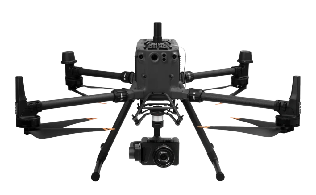
    Industrial Photogrammetry UAV System — DJI Matrice 350 + TOPODRONE P24 + PPK

    Image 10. Industrial Photogrammetry UAV System — DJI Matrice 350 + TOPODRONE P24 Camera + PPK

    Data processing and final deliverables

    The data were processed using Bentley ContextCapture — one of the leading industrial photogrammetry software solutions. The result includes:

    • A textured 3D mesh;
    • A point cloud;
    • A metrically accurate model, ready for integration into BIM and CAD systems.

    The overview model is not a final product but a working foundation. Documenting micro-cracks, chips, and fine carving will require additional surveys with GSD < 5 mm/pixel. However, at this stage, the structure, geometry, and form of the monument are available in a stable digital format.

    Video 1. Overview 3D Model of Jvari Monastery

    Digital twin as a tool for assessment and planning

    The created 3D model of Jvari Monastery is:

    • An accurate digital archive of the current state;
    • A tool for preventive monitoring, enabling detection of hidden deformations;
    • A reference for restoration actions;
    • The geometric basis for H-BIM, to which all future data about the site can be linked.

    The overview model provides specialists with a spatial understanding of the monument, allows prioritisation, and significantly reduces risks during preparation. It forms the basis for accurate, timely, and careful decision-making, including in the preservation of unique architectural heritage sites.

    Overview 3D model of Jvari Monastery

    Image 11. Overview 3D model of Jvari Monastery

    • Comments
    Loading comments ...
    Back to the list
    Subscribe to the newsletter of our news and stocks
    Subscribe to
    Connect with us
    +41 21 588 02 11
    +41 21 588 02 11 09:00-18:00 whatsapp.svg
    Sales [email protected] email.png
    Support [email protected] email.png
    Telegram Channel @topodronesa tg.svg
    Telegram Chat @topodronesagroup tg.svg
    Telegram Bot @topodronecombot tg.svg
    Facebook @topodronesa ycz1c9257s6gh7g315r8q6tob3bnddba.png
    Youtube @topodronesa youtube.png
    LinkedIn @topodrone 9ratq3v3eavnhupo1akvxp0sbx4vopj5.png
    X @topodrone twitter.png
    Instagram @topodrone tpxkj71axu6dxt423lwj5idzwcej1njx.png
    Email
    [email protected] - Sales
    [email protected] - Support
    The address
    TOPODRONE SA, Rue de la Gare 13, 1820 Montreux, Switzerland
    Working hours
    10:00-18:00
    [email protected] - Sales
    [email protected] - Support
    TOPODRONE SA, Rue de la Gare 13, 1820 Montreux, Switzerland
    Products
    Sales
    Brands
    Services
    Applications
    Company
    Staff
    News
    Reviews
    Vacancy
    Licenses
    Documents
    Partners
    Information
    Requisites
    Help
    Payment
    Delivery
    Warranty
    FAQ
    © 2026 TOPODRONE SA
    Privacy Policy
    Main page Product 0 Comparison Contacts Blog Applications