





Knowledge base
Blog
Services
  • Aerial Photography
    • UAV Monitoring & Inspections
    • UAV Photogrammetry
  • Laser Scanning
    • Aerial Laser Scanning
    • Quarry Surveying
    • Topographical Surveying
  • Training
    • UAV Pilot Course: Photogrammetry & ALS
Company
  • Staff
  • News
  • Reviews
  • Vacancy
  • Licenses
  • Documents
  • Partners
Information
  • Requisites
Brands
Contacts
    +41 21 588 02 11
    +41 21 588 02 11 09:00-18:00 whatsapp.svg
    Sales [email protected] email.png
    Support [email protected] email.png
    Telegram Channel @topodronesa tg.svg
    Telegram Chat @topodronesagroup tg.svg
    Telegram Bot @topodronecombot tg.svg
    Facebook @topodronesa ycz1c9257s6gh7g315r8q6tob3bnddba.png
    Youtube @topodronesa youtube.png
    LinkedIn @topodrone 9ratq3v3eavnhupo1akvxp0sbx4vopj5.png
    X @topodrone twitter.png
    Instagram @topodrone tpxkj71axu6dxt423lwj5idzwcej1njx.png
    Email
    [email protected] - Sales
    [email protected] - Support
    The address
    TOPODRONE SA, Rue de la Gare 13, 1820 Montreux, Switzerland
    Working hours
    10:00-18:00
    TOPODRONE
    SPH Engineering
    3Dsurvey
    Velodyne
    DJI
    GreenValley International
    Honeywell
    Fixar
    Blue Marble Geographics
    Sony
    Agisoft
    EMLID
    Pix4D
    Autel Robotics
    SHAREUAV
    • LiDAR
      LiDAR
      • Aerial Survey LiDAR
      • SLAM Survey LiDAR
      • LiDAR Accessories
    • Bathymetry
      Bathymetry
    • Photogrammetry
      Photogrammetry
      • Mapping Drones
      • Drone Mapping Cameras
      • VTOL Mapping Cameras
    • PPK Upgrade Kits
      PPK Upgrade Kits
      • PPK for Drones
      • PPK for any UAV
    • Spectrography
      Spectrography
      • Thermal
      • Multispectral
    • UAV
      UAV
      • DJI
      • Autel Robotics
      • FIXAR
      • Innotech drone
    • Payload
      Payload
      • Aerial Survey LiDAR
      • Bathymetric Scanner
      • Photogrammetric Cameras
      • Thermal Cameras
      • Multispectral Cameras
      • Beacon
    • Software
      Software
      • TOPODRONE
      • UgCS
      • Agisoft
      • 3Dsurvey
      • LiDAR360
      • DJI
      • PIX4D
    • GNSS Equipment
      GNSS Equipment
      • EMLID
      • DJI
    TOPODRONE – LiDAR & UAV Survey
    Log in
    0 Comparison
    0 Favorites
    0 Cart
    TOPODRONE – LiDAR & UAV Survey
    Log in
    0 Comparison
    0 Favorites
    0 Cart
    TOPODRONE – LiDAR & UAV Survey
    Telephones
    +41 21 588 02 11 09:00-18:00 whatsapp.svg
    Sales [email protected] email.png
    Support [email protected] email.png
    Telegram Channel @topodronesa tg.svg
    Telegram Chat @topodronesagroup tg.svg
    Telegram Bot @topodronecombot tg.svg
    Facebook @topodronesa ycz1c9257s6gh7g315r8q6tob3bnddba.png
    Youtube @topodronesa youtube.png
    LinkedIn @topodrone 9ratq3v3eavnhupo1akvxp0sbx4vopj5.png
    X @topodrone twitter.png
    Instagram @topodrone tpxkj71axu6dxt423lwj5idzwcej1njx.png
    Email
    [email protected] - Sales
    [email protected] - Support
    The address
    TOPODRONE SA, Rue de la Gare 13, 1820 Montreux, Switzerland
    Working hours
    10:00-18:00
    0
    0
    0
    • Cabinet
    • 0 Compare
    • 0 Favorite
    • 0 Cart
    • Brands
    • Sales
    • Services
      • Services
      • Aerial Photography
        • Aerial Photography
        • UAV Monitoring & Inspections
        • UAV Photogrammetry
      • Laser Scanning
        • Laser Scanning
        • Aerial Laser Scanning
        • Quarry Surveying
        • Topographical Surveying
      • Training
        • Training
        • UAV Pilot Course: Photogrammetry & ALS
    • Company
      • Company
      • Staff
      • News
      • Reviews
      • Vacancy
      • Licenses
      • Documents
      • Partners
    • Blog
    • Information
      • Information
      • Requisites
    • Contacts
    +41 21 588 02 11 09:00-18:00
    • Telephones
    • +41 21 588 02 11 09:00-18:00
      whatsapp.svg
    • Sales [email protected]
      email.png
    • Support [email protected]
      email.png
    • Telegram Channel @topodronesa
      tg.svg
    • Telegram Chat @topodronesagroup
      tg.svg
    • Telegram Bot @topodronecombot
      tg.svg
    • Facebook @topodronesa
      ycz1c9257s6gh7g315r8q6tob3bnddba.png
    • Youtube @topodronesa
      youtube.png
    • LinkedIn @topodrone
      9ratq3v3eavnhupo1akvxp0sbx4vopj5.png
    • X @topodrone
      twitter.png
    • Instagram @topodrone
      tpxkj71axu6dxt423lwj5idzwcej1njx.png
    • [email protected] - Sales
      [email protected] - Support
    • TOPODRONE SA, Rue de la Gare 13, 1820 Montreux, Switzerland
    • 10:00-18:00
    Main
    Blog
    DJI Phantom 4Pro RTK/ PPK UAV survey for design & construction in Switzerland

    DJI Phantom 4Pro RTK/ PPK UAV survey for design & construction in Switzerland

    DJI Phantom 4Pro RTK/ PPK UAV survey for design & construction in Switzerland
    11 February 2019

    Today we are going to continue the theme how to use UAV for design and construction and now you have chance to look at a real survey in the canton of Vaud in Switzerland.

    AGRUS SA, which developments and buildings wide range of Real Estate and Business Projects including Design Real Estate Projects from the initial idea to the final construction project, ask our team to make a survey in purpose to get precise and detailed 3D models of land plots and infrastructure around this area for further designing and promotion material creating.

    14.jpg

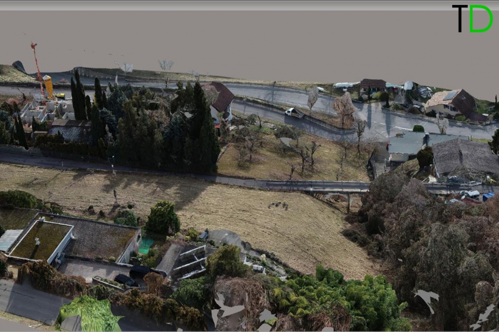
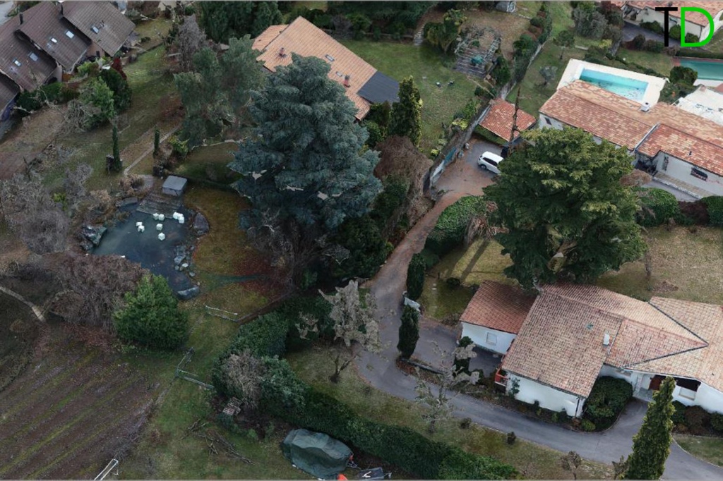
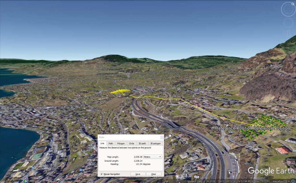
    All land plots of new development projects are located in the foothills in close proximity to Lake Geneva with beautiful views to mountains and lake. (Pic.1,2)

    We offered advanced drone technology that allows to survey large areas of land more accurately and faster than conventional survey techniques, providing clients with 3D models, contours and digital elevation models with rapid turnaround.

    Survey and Data Processing

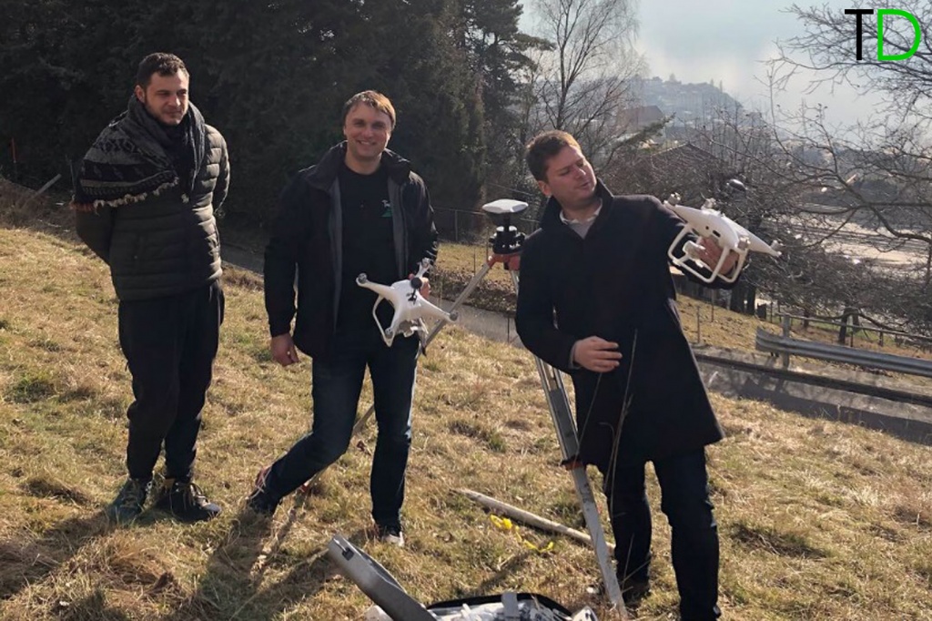
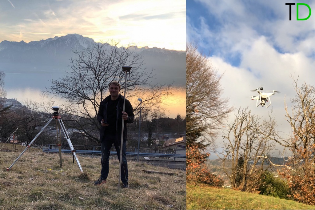
    The following equipment and software were used for surveying (Pic.3.4):

    1. Two pieces of EMLID Reach RS+ GNSS receivers.
    2. DJI PHANTOM 4PRO PPKupgraded by Topodrone SA with additionally installed GNSS receiver connected to the camera.
    3. the
    4. Pix4Dmapper software for 3D modelling, RTKlib GNSS data for post-processing and TOPOSETTER APP for geotagging images.
    3546.jpg

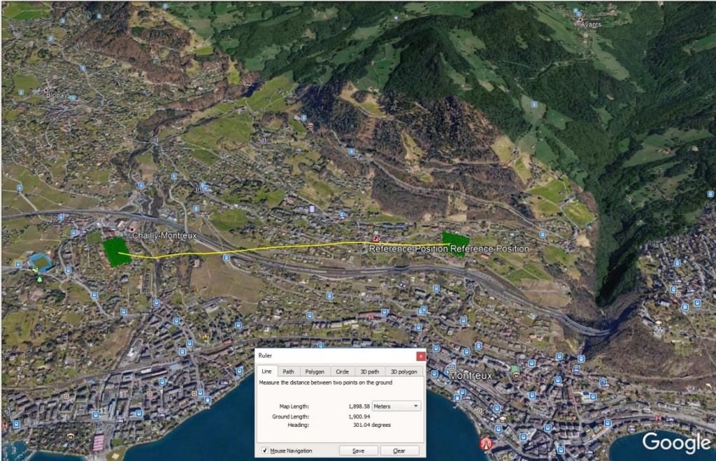
    Rice.1. Location of the 1st and 2nd work site
    6864.jpg

    Pic.2.  3D view of Area 1 and Area 2 location.

    On the first stage Reach RS+ was installed on the tripod on the point with known coordinates. This GNSS receiver was used as a base for measuring ground check points (GCP) in RTK mode by the second REACH RS+ and this base station were collecting raw Rinex data in static mode during flights.
    10.jpg

    Pic.3.4. DJI PHANTOM 4PRO PPK, EMLID REACH RS+ GNSS receiver.

    On the first day we surveyed two different areas located within 2 km range from each other without a direct view. For time saving for the flights over area #1we used a base station installed in area #2. All flights and field works did not take a lot of time and were accomplished within one hour.

    After flights GNSS data from the drone were downloaded and post processed together with Rinex file from the base station in order to get accurate coordinates of each image location. Finally we assigned accurate coordinates to each image to EXIF by TOPOSETTER APP.

    Photogrammetry processing was made by Pix4D software without using GCP.

    In general there are the following easy steps in Pix4Dmapper:

    • Import images together with accurate images coordinates and GCPs
    • Run initial processing to find tie points and to optimize internal and external parameters
    • Set up calibrated external camera parameters
    • Reoptimize photos
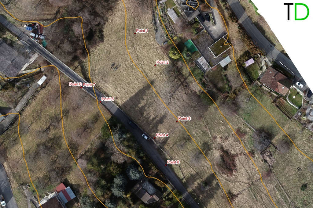
    • Check accuracy by defining check points location (Pic.5,6). Accuracy report is represented in Tab.1
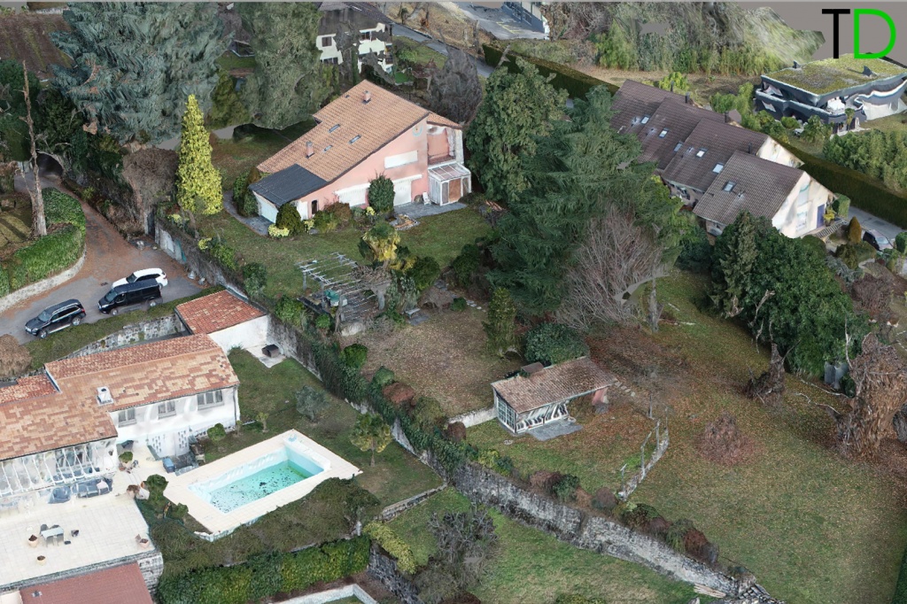
    • Run Points cloud, DTM, DSM and orthophoto creation (Pic.7-12)

    At the final stage results of aerial photo triangulation was checked by measured check points.

    2.jpg

    Pic.5. Defining check points location in PIX4D.

    17.jpg

    Pic.6. Ground check points location


    7.jpg

    Tab.1. Accuracy report.

    Fig.7. Dense point cloud

    Pic.7. Sense points cloud.


    5.jpg

    Pic.8. Sense points cloud classification.

    3.jpg

    Pic.9. 3D model of area 2.

    11.jpg

    Rice.10. 3D model of the second section of work
    9.jpg

    Pic.11. 3D model of area 2.

    15.jpg

    Pic.12. 3D model of area 2.


    Resume

    As a result of this survey we got high-resolution and high-precise 3D model which was highly rated by ARGUS SA. They will use this model in a construction project.


    Email us if you want a detailed guide to high-precision data processing in Pix4D.

    • Comments
    Loading comments ...
    Back to the list
    Subscribe to the newsletter of our news and stocks
    Subscribe to
    Connect with us
    +41 21 588 02 11
    +41 21 588 02 11 09:00-18:00 whatsapp.svg
    Sales [email protected] email.png
    Support [email protected] email.png
    Telegram Channel @topodronesa tg.svg
    Telegram Chat @topodronesagroup tg.svg
    Telegram Bot @topodronecombot tg.svg
    Facebook @topodronesa ycz1c9257s6gh7g315r8q6tob3bnddba.png
    Youtube @topodronesa youtube.png
    LinkedIn @topodrone 9ratq3v3eavnhupo1akvxp0sbx4vopj5.png
    X @topodrone twitter.png
    Instagram @topodrone tpxkj71axu6dxt423lwj5idzwcej1njx.png
    Email
    [email protected] - Sales
    [email protected] - Support
    The address
    TOPODRONE SA, Rue de la Gare 13, 1820 Montreux, Switzerland
    Working hours
    10:00-18:00
    [email protected] - Sales
    [email protected] - Support
    TOPODRONE SA, Rue de la Gare 13, 1820 Montreux, Switzerland
    Products
    Sales
    Brands
    Services
    Applications
    Company
    Staff
    News
    Reviews
    Vacancy
    Licenses
    Documents
    Partners
    Information
    Requisites
    Help
    Payment
    Delivery
    Warranty
    FAQ
    © 2026 TOPODRONE SA
    Privacy Policy
    Main page Product 0 Comparison Contacts Blog Applications