Knowledge base
Blog
Services
  • Aerial Photography
    • UAV Monitoring & Inspections
    • UAV Photogrammetry
  • Laser Scanning
    • Aerial Laser Scanning
    • Quarry Surveying
    • Topographical Surveying
  • Training
    • UAV Pilot Course: Photogrammetry & ALS
Company
  • Staff
  • News
  • Reviews
  • Vacancy
  • Licenses
  • Documents
  • Partners
Information
  • Requisites
Brands
Contacts
    +41 21 588 02 11
    +41 21 588 02 11 09:00-18:00 whatsapp.svg
    Sales [email protected] email.png
    Support [email protected] email.png
    Telegram Channel @topodronesa tg.svg
    Telegram Chat @topodronesagroup tg.svg
    Telegram Bot @topodronecombot tg.svg
    Facebook @topodronesa ycz1c9257s6gh7g315r8q6tob3bnddba.png
    Youtube @topodronesa youtube.png
    LinkedIn @topodrone 9ratq3v3eavnhupo1akvxp0sbx4vopj5.png
    X @topodrone twitter.png
    Instagram @topodrone tpxkj71axu6dxt423lwj5idzwcej1njx.png
    Email
    [email protected] - Sales
    [email protected] - Support
    The address
    TOPODRONE SA, Rue de la Gare 13, 1820 Montreux, Switzerland
    Working hours
    10:00-18:00
    TOPODRONE
    SPH Engineering
    3Dsurvey
    Velodyne
    DJI
    GreenValley International
    Honeywell
    Fixar
    Blue Marble Geographics
    Sony
    Agisoft
    EMLID
    Pix4D
    Autel Robotics
    SHAREUAV
    • LiDAR
      LiDAR
      • Aerial Survey LiDAR
      • SLAM Survey LiDAR
      • LiDAR Accessories
    • Bathymetry
      Bathymetry
    • Photogrammetry
      Photogrammetry
      • Mapping Drones
      • Drone Mapping Cameras
      • VTOL Mapping Cameras
    • PPK Upgrade Kits
      PPK Upgrade Kits
      • PPK for Drones
      • PPK for any UAV
    • Spectrography
      Spectrography
      • Thermal
      • Multispectral
    • UAV
      UAV
      • DJI
      • Autel Robotics
      • FIXAR
      • Innotech drone
    • Payload
      Payload
      • Aerial Survey LiDAR
      • Bathymetric Scanner
      • Photogrammetric Cameras
      • Thermal Cameras
      • Multispectral Cameras
      • Beacon
    • Software
      Software
      • TOPODRONE
      • UgCS
      • Agisoft
      • 3Dsurvey
      • LiDAR360
      • DJI
      • PIX4D
    • GNSS Equipment
      GNSS Equipment
      • EMLID
      • DJI
    TOPODRONE – LiDAR & UAV Survey
    Log in
    0 Comparison
    0 Favorites
    0 Cart
    TOPODRONE – LiDAR & UAV Survey
    Log in
    0 Comparison
    0 Favorites
    0 Cart
    TOPODRONE – LiDAR & UAV Survey
    Telephones
    +41 21 588 02 11 09:00-18:00 whatsapp.svg
    Sales [email protected] email.png
    Support [email protected] email.png
    Telegram Channel @topodronesa tg.svg
    Telegram Chat @topodronesagroup tg.svg
    Telegram Bot @topodronecombot tg.svg
    Facebook @topodronesa ycz1c9257s6gh7g315r8q6tob3bnddba.png
    Youtube @topodronesa youtube.png
    LinkedIn @topodrone 9ratq3v3eavnhupo1akvxp0sbx4vopj5.png
    X @topodrone twitter.png
    Instagram @topodrone tpxkj71axu6dxt423lwj5idzwcej1njx.png
    Email
    [email protected] - Sales
    [email protected] - Support
    The address
    TOPODRONE SA, Rue de la Gare 13, 1820 Montreux, Switzerland
    Working hours
    10:00-18:00
    0
    0
    0
    • Cabinet
    • 0 Compare
    • 0 Favorite
    • 0 Cart
    • Brands
    • Sales
    • Services
      • Services
      • Aerial Photography
        • Aerial Photography
        • UAV Monitoring & Inspections
        • UAV Photogrammetry
      • Laser Scanning
        • Laser Scanning
        • Aerial Laser Scanning
        • Quarry Surveying
        • Topographical Surveying
      • Training
        • Training
        • UAV Pilot Course: Photogrammetry & ALS
    • Company
      • Company
      • Staff
      • News
      • Reviews
      • Vacancy
      • Licenses
      • Documents
      • Partners
    • Blog
    • Information
      • Information
      • Requisites
    • Contacts
    +41 21 588 02 11 09:00-18:00
    • Telephones
    • +41 21 588 02 11 09:00-18:00
      whatsapp.svg
    • Sales [email protected]
      email.png
    • Support [email protected]
      email.png
    • Telegram Channel @topodronesa
      tg.svg
    • Telegram Chat @topodronesagroup
      tg.svg
    • Telegram Bot @topodronecombot
      tg.svg
    • Facebook @topodronesa
      ycz1c9257s6gh7g315r8q6tob3bnddba.png
    • Youtube @topodronesa
      youtube.png
    • LinkedIn @topodrone
      9ratq3v3eavnhupo1akvxp0sbx4vopj5.png
    • X @topodrone
      twitter.png
    • Instagram @topodrone
      tpxkj71axu6dxt423lwj5idzwcej1njx.png
    • [email protected] - Sales
      [email protected] - Support
    • TOPODRONE SA, Rue de la Gare 13, 1820 Montreux, Switzerland
    • 10:00-18:00
    Main
    Blog
    Aerial surveying with Topodrone DJI Mavic 2 Pro RTK/PPK

    Aerial surveying with Topodrone DJI Mavic 2 Pro RTK/PPK

    Aerial surveying with Topodrone DJI Mavic 2 Pro RTK/PPK
    16 September 2019

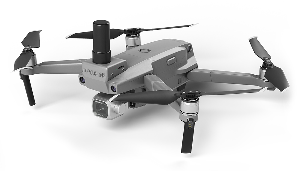
    This article describes a process of aerial surveying with a Topodrone DJI Mavic 2 Pro L1/L2 RTK/PPK equipped with a 186-channel L1/L2 GPS/GLONASS GNSS receiver.


    A good illustration of that is a real project of a mining site survey with a total area of 180ha. It is located in a rugged terrain with mountain slopes and a huge number of buildings, plants, vehicles at an altitude of 1000 m above the sea level.

    A poor mobile coverage and ever-changing terrain make the surveying task even harder to complete.

    Due to poor communication the common software like DJI GS Pro, Pix4Dcapture and MapPilot has no use. For this reason, we chose the UgCS tool suite.

    This product has convenient tools for professional mission planning and drone control via laptop. It provides fully autonomous functioning mode with no internet connection needed. Moreover, it can obtain flight trajectories based on the custom terrain data.

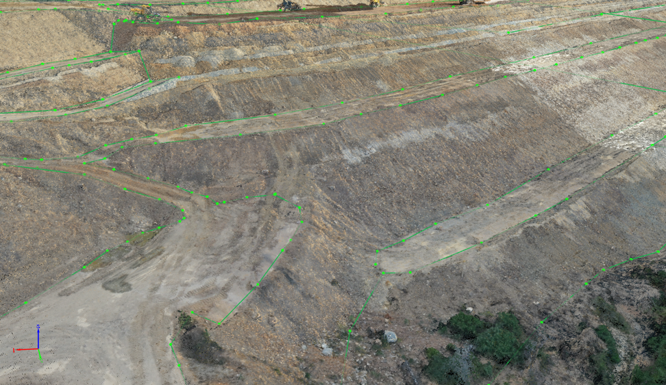
    We have described mission planning in our previous article (see the link at the end of the page). Img.3 presents an example of planned flight routes.


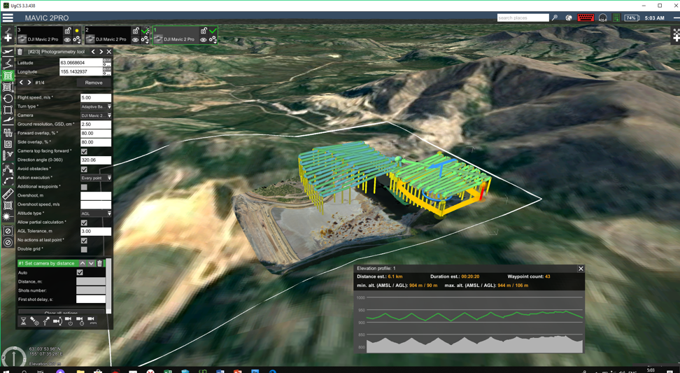
    Img. 3 An example of planned flight routes in UgGS. 

    After the preparation we set to field work. At the point with well-known coordinates we mounted base station and started recording static data.


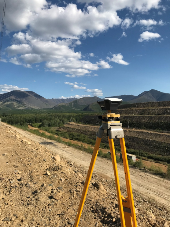
    Img. 4 Base station mounted on a point with known coordinates

    Then we performed flights with the Topodrone DJI Mavic 2 Pro L1/L2 RTK/PPK. All field work at the area of more than 180ha took several hours to complete.

    We were pleasantly surprised by user friendliness and simplicity of the drone. It has a quite small weight, failsafe software and an awesome high-resolution Hasselblad camera.

    Next, we obtained logs from the drone and the base station, performed GNSS measurement post-processing with the TOPOSETTER software. We have provided a detailed description of this process in our previous articles. The TOPOSETTER software allows user to assign accurate coordinates to images, delete redundant images that were taken in a short timespan, compensates an antenna tilt during flight. That makes it the most appropriate tool for this task.

    For the photogrammetric data handling we chose the Pix4Dmapper tool suite.


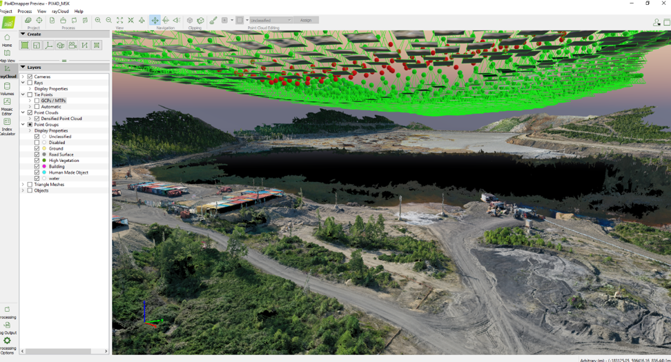
    Img. 5: photogrammetric data handling in Pix4Dmapper.

    It has the following key features: the ability of high-precision aerial triangulation and rolling shutter distortion compensation, creating a dense point cloud and advanced technologies for its classification.


    After uploading images and their high-accuracy coordinates into the project, completing the triangulation step (determining change points, calculating the image inner orientation parameters, compensated distortion after rolling shutter use) we checked the accuracy of image block processing with already known control points.

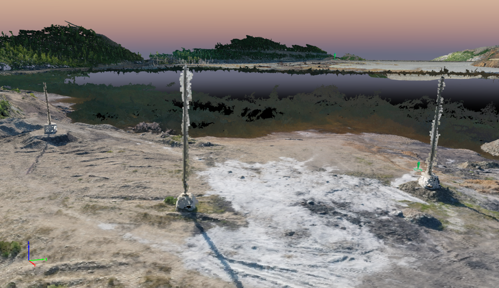
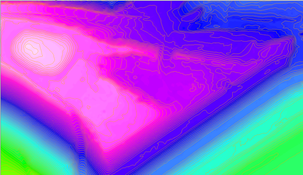
    It is safe to say that at the altitude of 90m the point cloud shows light poles, electric lines, barriers, trestles, separate buildings and structures, trees and flora. This point cloud is as detailed as LIDAR scanning results and automatic classification tools allow recognizing objects like roads, flora, buildings, leads and ground. These tools save time and efforts during data processing and minimize hand labor during terrain recognition, getting DTM and contour lines.

    Images 7-18 show the examples of the high-detailed point clouds.


    Img 7: Point cloud with barriers, gates, piles, and power lines.


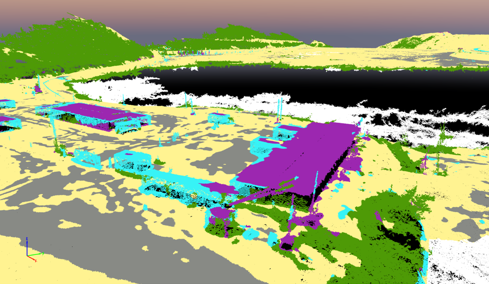
    Img 8: Classified point cloud.


    Img 9: Point clout with piles, trestles, buildings and vehicles.


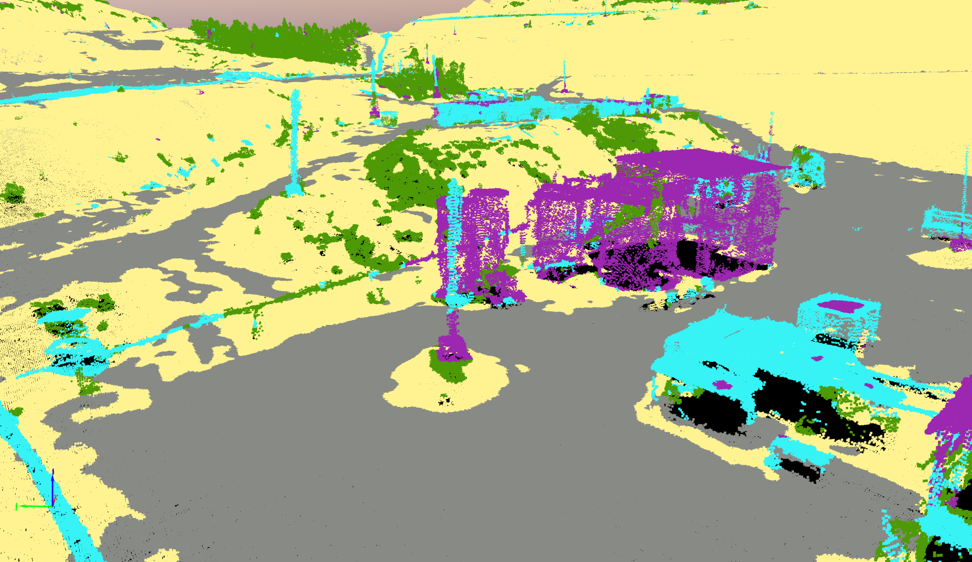
    Img 10: Classified point cloud.


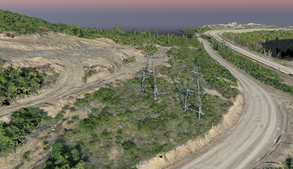
    Img 11: Point cloud with flora, power lines, roads, bases of slopes and brows.


    Img 12: Classified point cloud.


    Img 13: Point cloud with warehousing facilities, light guard group and gates.


    Img 14: Classified point cloud.


    Img 15: Point cloud with dense flora


    Img 16: Point cloud with automatically flora


    Img 17: Point cloud with tubes and their position above ground.


    Img 18: Point cloud with piles on a concrete basement

    On the next step we started to prepare the map. Using vectorization tools included into Pix4Dmapper we digitalized roads, brows and bases of slopes, drainage, barriers, constructions and buildings. Digitalizing results are on img 19-21.


    Img 19: Pix4Dmapper vectoring tools digitalizing results.


    Img 20: Pix4Dmapper vectoring tools digitalizing results.


    Img 21: Pix4Dmapper vectoring tools digitalizing results.

    After the automatic cloud point classification we created a digital terrain model, contour lines and prepared orthophotomosaic. The result is given on pictures 22 and 23.


    Img 22: The digital terrain and the contour lines model.


    Img 23: Orthophotomosaic and the contour lines.

    On the final stage we imported vector dataset (contour lines, terrain elements, roads, drainage, barriers, buildings and constructions, power lines, tubes, trestles, etc.) with orthophoto into AutoCAD Map 3D for creating a map layout.


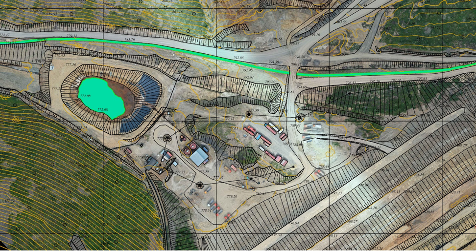
    Img 24: Topographic map with orthophotomosaic.


    Img 25: Topographic map with orthophotomosaic.


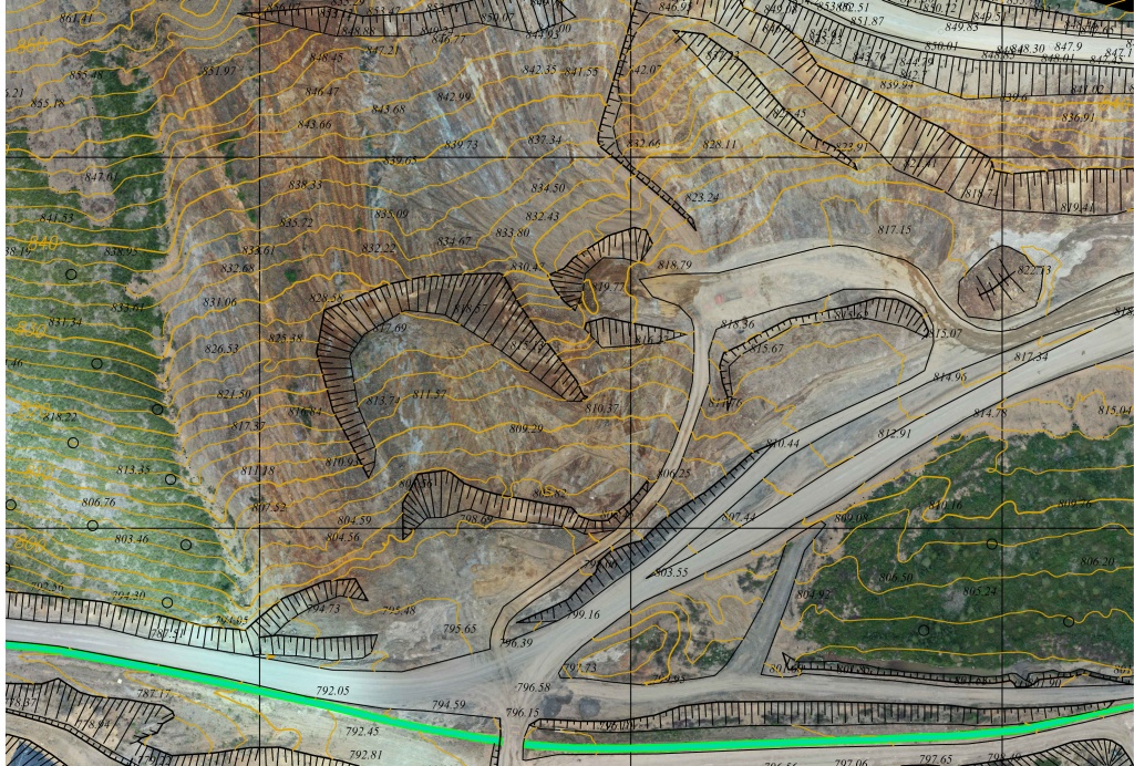
    Img 26: Topographic map with orthophotomosaic.

    Conclusion

    The successful realization of the project shows the potential of using Topodrone DJI Mavic 2 Pro L1/L2 RTK/PPK for surveying. Although the device is the smallest among the survey drones, available at the market, it provides high accuracy for 3D modelling and topographic mapping up to 1:500 scale.

    The use of this tool with professional planning and guiding software UgCS guarantees the accomplishment of the mission even in especially harsh conditions.

    Pix4Dmapper software provides high-accurate photogrammetric plotting, detailed point cloud generation and its automatic classification. The highest point cloud quality, depicting piles, fences, trestles, buildings and constructions allows creating a topographic plan in office conditions. It saves time and expenses whereas automatic point classification technologies make office work easy and simple.

    • Comments
    Loading comments ...
    Back to the list
    Subscribe to the newsletter of our news and stocks
    Subscribe to
    Connect with us
    +41 21 588 02 11
    +41 21 588 02 11 09:00-18:00 whatsapp.svg
    Sales [email protected] email.png
    Support [email protected] email.png
    Telegram Channel @topodronesa tg.svg
    Telegram Chat @topodronesagroup tg.svg
    Telegram Bot @topodronecombot tg.svg
    Facebook @topodronesa ycz1c9257s6gh7g315r8q6tob3bnddba.png
    Youtube @topodronesa youtube.png
    LinkedIn @topodrone 9ratq3v3eavnhupo1akvxp0sbx4vopj5.png
    X @topodrone twitter.png
    Instagram @topodrone tpxkj71axu6dxt423lwj5idzwcej1njx.png
    Email
    [email protected] - Sales
    [email protected] - Support
    The address
    TOPODRONE SA, Rue de la Gare 13, 1820 Montreux, Switzerland
    Working hours
    10:00-18:00
    [email protected] - Sales
    [email protected] - Support
    TOPODRONE SA, Rue de la Gare 13, 1820 Montreux, Switzerland
    Products
    Sales
    Brands
    Services
    Applications
    Company
    Staff
    News
    Reviews
    Vacancy
    Licenses
    Documents
    Partners
    Information
    Requisites
    Help
    Payment
    Delivery
    Warranty
    FAQ
    © 2026 TOPODRONE SA
    Privacy Policy
    Main page Product 0 Comparison Contacts Blog Applications