Using TOPODRONE LiDAR 100 Lite for operational quarries and bulk materials warehouses surveying
Over the past few years the use of aerial survey from drones for the determination of volumes and mapping has become a widespread practice. Literally every day more and more organizations are putting into practice all the advantages of drones which allow you to reduce the time of field work and their cost tenfold.
At the last online conference Autodesk Drone Day organized by the world leader in software development company Autodesk, the participants shared their experience in the survey organization and performing, talked about the possibilities of legalizing the use of drones and the approval of the methodology.
All these examples are associated with the use of aerial survey and photogrammetric methods for creating a 3D model of the terrain. The advantages of this technology include accessibility and low cost, for example, a set of survey drone TOPODRONE DJI Mavic 2 Pro PPK costs $3580, provides accuracy of 3-5 cm XYZ.
On the other hand, the use of aerial survey has weaknesses and limitations, such as the dependence of image quality on the illumination of the area, the inability to perform work at dusk or dark, the inability to plot the terrain surface in high vegetation and in the territory covered with forest, high demands on computing resources, a long process of generating a dense point cloud, which can take from several hours to tens of days, a rather complex processing technology that requires professional knowledge in the field of GNSS post-processing, photogrammetry, image alignment and camera calibration.
And almost none of these limitations, unlike photogrammetry, are not affect to laser scanning technology. Today we will show you a real example of quarry aerial laser scanning for operational monitoring, mapping and volumes calculation.

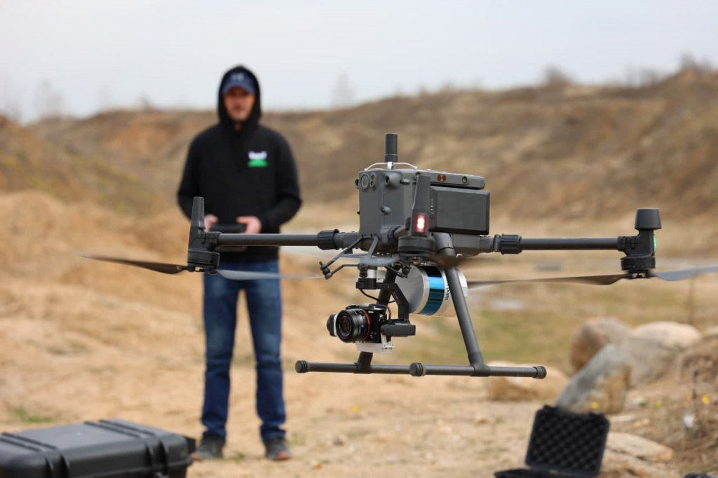
Pic. 1. TOPODRONE LiDAR 100 Lite integrated with TOPODRONE DJI Enterprise PPK Upgrade Kit and camera Sony RX1R II 42Mp on 3-axis gimbal.
To perform this project we used TOPODRONE LiDAR 100 Lite integrated with TOPODRONE DJI Enterprise PPK Upgrade Kit and camera Sony RX1R II 42Mp.
At the first stage we planned laser scanning routes in professional flight planning software UgCS Pro, which encircle the real rugged terrain of the quarry.

Pic. 2. Planning laser scanning routes in professional flight planning software UgCS Pro.
Then we prepared the base station. As a base station we chose one of the most affordable and easy-to-use GNSS receiver EMLID Reach RS2.
Then we measured the GCPs. Looking ahead, we would like to say that the GCPs were used only for accuracy control and were not used for data processing.

Pic. 3. Base station setting.

Pic. 4. Getting GCPs.
We prepared the drone, installed a TOPODRONE LiDAR 100 Lite and TOPODRONE DJI Enterprise PPK Upgrade Kit with a Sony RX1R II 42 Mp camera. It is important to note that the integration of the equipment does not take much time and does not require special skills, while standard DJI Skyport connectors are used, power is supplied from the on-board system of the drone, and the control of autofocus and camera shutter is carried out automatically through the mission application installed on the remote control of the drone.

Pic. 5. Preparing the equipment for survey.
At the next stage the flights were performed completely in automatic mode from the takeoff to landing. After completing the flight we downloaded the data and started processing it, which can be divided into the following stages:
- Post-processing of GNSS data together with IMU, generation of a high-precision trajectory with IMU 200 Hz frequency (200 times per second).
- Generating a dense point cloud from TOPODRONE LiDAR 100 Lite in the local coordinate system.
- Aerial laser scanning routes alignment, classification, generating of terrain surface and counter lines.
For GNSS and IMU data post-processing and generating a dense point cloud we used TOPOLiDAR software with a Post Processing module, which supports various formats of base stations, has a simple and easy-to-use interface, has automation tools, allows you to perform data batch processing, i.e. several flights at once in one session, and also generates a dense point cloud in a chosen local coordinate system.
Pay special attention to the speed of post-processing data and creating a highly detailed dense point cloud. On average this process takes no more than 5 minutes, compared to tens of hours or even days when using photogrammetry technology.

Pic. 6. TOPOLiDAR software interface.

Pic. 7. Trajectory Visualization module interface.
In the next step we loaded the generated dense point cloud into the LiDAR360 software, performed route alignment, colored the cloud in real RGB colors and also performed classification and selection of the terrain surface.

Pic. 8. 3D model of the terrain obtained from laser scanning.

Pic. 9. Dense point cloud colored in RGB colors.

Pic. 10. Digital terrain model DSM, clearly visible outliers on the height matrix in the trees location area.

Pic. 11. Digital terrain model DTM based on an automatically classified terrain surface.

Pic. 12. Counter lines created from the classified terrain surface.
The entire processing from the first stage to obtaining the classified terrain surface was completed within 15 minutes, while all vegetation was classified completely automatically, which is an unattainable parameter for photogrammetry technology.
At the final stage we loaded the GCPs and checked their position relative to the 3D model. The accuracy was 2-4 cm XYZ.
Conclusions
TOPODRONE LiDAR 100 Lite equipment has an affordable price, does not require powerful computing resources, provides high accuracy and unattainable for photogrammetry opportunities on terrain covered with high vegetation, as well as unprecedented data processing speed, when the phrase "operational monitoring" takes on a real meaning - to get data within a few tens of minutes after the flight.
|
Start cooperation with an individual consultation on the selection of equipment and services.
|
Order service
|


.png)


