TOPOSETTER 2.0 PRO - successfully tested in Israel
TOPOSETTER 2 PRO software helps to create 3D model with 1-3 cm x,y,z accuracy in Israel local coordinate system (IGD 05/12).

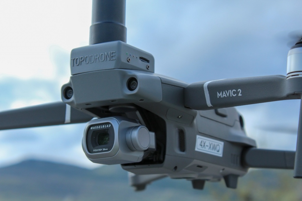
Pic 1. Topodrone DJI Mavic 2 Pro L1/L2 RTK/PPK.
In the article below, we want to present you our latest software development, which is designed to greatly automate and simplify the GNSS measurements processing and initial preparation of aerial photography materials for subsequent photogrammetric processing.
We will show all the main features of our new product based on project, were carried out by our advanced users and partners from Israel Geoscan Ltd. Advanced UAS Service & Solutions
The Geoscan Ltd. (CAAIL- Air Operation Certificate No: 088292019) is a highly professional user of TOPODRONE solutions, in particular the DJI Mavic 2 Pro L1 / L2 RTK / PPK. Geoscan Ltd. has a huge experience of service providing in complicated projects of precise geodetic surveys and measurements by using UAS based solutions, as well as DJI Phantom 4 RTK (Alternative solution).
We have selected an area with more than 200 measured GCPs for testing. These GCPs will be used for coordinate and terrain 3D-model quality control

Pic 2. Location of the work area and control points..
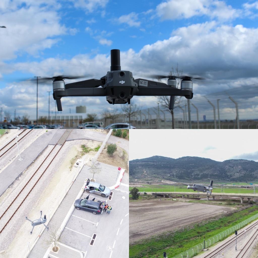
Aerial photography was performed by Topodrone DJI Mavic 2 Pro L1/L2 RTK/PPK from a height of 40 meters at a speed of about 4 m/s without installing a GNSS base station.

Pic 3. Topodrone DJI Mavic 2 Pro L1/L2 RTK/PPK in action.
Post-processing of GNSS measurements and georeferencing of images are easy!
We have downloaded a virtual Rinex file from the web-site www.etkes.com before the data processing. It was coincided by a time with the aerial photography and drone’s .ubx data.
It should be noted that the territory of Israel is completely covered by a network of base stations, whose data is available via the Internet. So there is no need to install a base station or connect a drone to the NTRIP service via the Internet to work in RTK mode during survey. It is just enough to simply download a virtual Rinex file after flights with the coordinates of the base station within the area of interest.
- Roman Kirsanov Co-Founder & CEO Geoscan Ltd

Pic. 4. The scheme of GNSS base stations coverage in Israel.
Next the following data set was loaded in the TOPSETTER 2.0 Pro software:
-
Folder with images of the first flight
-
UBX file from the drone
-
Rinex file from the base station
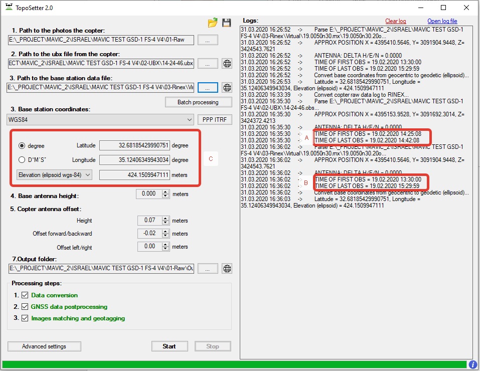
During the import, an information window shows the start and the end time of GNSS measurements of the base station and the drone, as well as the coordinates of the base station in the WGS84 system.

Pic. 5. Updated TOPOSETTER 2.0 Pro interface.
After entering all the source data, we selected the output ISRAEL IGD 05/12 coordinate system . Also, we set the necessary elevation system, and launched the automated post-processing of GNSS measurements and images georeferencing.
ISRAEL IGD 05/12 coordinate system was added to TOPOSETTER 2.0 Pro App with using an official information from government agency for Mapping, Geodesy, Cadaster and Geoinformatics www.mapi.gov.il.

Pic. 6. TOPOSETTER 2.0 Pro, selecting the output coordinate system.
The following data set was obtained based on the results of post processing:
-
Geotagged images in EXIF tags (Latitude, Longitude, Ellipsoid height and accuracy)
-
Text files with images’ coordinates in WGS 84 and ISRAEL IGD 05/12 systems
1-3 cm xyz accuracy of the 3D model is real!
Next, we created a Pix4Dmapper project with a set of aerial photos. Pix4Dmapper automatically calculated the coordinates of the images and their accuracy.

Pic. 7. Automatic import of image coordinates and their accuracy.
Then we selected the Israel Grid 05/12 coordinate system, uploaded a text file with XYZ coordinates created as a result of post-processing in TOPOSETTER 2.0 Pro, and started the automatic aerotriangulation process.

Pic. 8. Loading data in the local coordinate system.
After completing the initial photogrammetric processing, we entered the calibrated focal length of the Topodrone DJI Mavic 2 Pro L1/L2 RTK/PPK camera and updated the aero triangulation.
Pay attention that all photogrammetric processing was performed using high-precision photo coordinates, which were calculated by the TOPOSETTER 2.0 Pro App in the Israel Grid 05/12 coordinate system without using any ground control points. Only at the next stage a set of GCP was loaded to assess the accuracy of the model construction.
- Roman Kirsanov Co-Founder & CEO Geoscan Ltd

Pic. 9. The control points and routes locations of aerial photography in Pix4Dmapper.
The processing report in Pix4Dmapper is presented below.
RMS errors on the XYZ axes were 1.15, 1.16 and 2.9 cm, which respond to the GNSS measurements accuracy in RTK mode.

Pic. 10. Accuracy control report of building a digital terrain model.
In the figures 11-14 show the results of comparing the position of control points on the orthophoto.

Pic. 11. The comparison results of the orthophotomap control points location.

Pic. 12. The comparison results of the orthophotomap control points location..

Pic. 13. The comparison results of the orthophotomap control points location.

Pic. 14. The comparison results of the orthophotomap control points location.
The advantages of TOPODRONE UAV solutions.
In the end, it should be noted that the results of this project clearly shows the advantages of using TOPODRONE UAV systems to perform high-precision survey.
We were really impressed what kind of accuracy was achieved.
1-3 cm x,y,z precision is a great result derived from the consumer drone DJI MAVIC 2 PRO upgraded by TOPODRONE system.
The technology of using virtual base stations eliminates the need to install a GNSS receiver as a ground base during flights and therefore reduces the initial cost of purchasing survey equipment.
- Roman Kirsanov Co-Founder & CEO Geoscan Ltd
TOPOSETTER 2.0 Pro allows post-processing of GNSS data in any coordinate systems set by a user, and provides a high level of accuracy.
The software has additional automatization capabilities that greatly reduce the quantity of manual work and save time allocated for preparing data for further photogrammetric processing:
-
Batch processing of multiple flights from a single base station
-
Automatic images renaming, which is very useful for large number of flights and aerial photography processing
-
The ability to save a text file with coordinates in formats compatible with Pix4Dmapper and Agisoft Metashape
-
Additional settings for GNSS measurements
-
The function for calculating the camera’s calibrated focal length
-
Loading coordinate systems from a PRJ file
-
Processing of the GNSS measurements in any coordinates system
-
Calculating the coordinates of the base station using PPP technology
Pay attention to the quality and detalization of the point cloud, which clearly shows curbs, posts, chain-link fences, railway tracks, and the terrain under vegetation.
- Roman Kirsanov Cofounder & CEO Geoscan Ltd

Pic. 15. Overview of a dense point cloud.

Pic. 16. Overview of a dense point cloud.

Pic. 17. Overview of a dense point cloud.

Pic. 18. Overview of a dense point cloud.

Pic. 19. Automatic point classification.
You can view the results of the project online by yourself
|
Start cooperation with an individual consultation on the selection of equipment and services.
|
Order service
|


.png)


