Training for UAV SURVEY & MAPPING with DJI Phantom 4PRO PPK
Training in geodesic aerial photography technology using DJI Phantom 4 Pro RTK/PPK
Today we would like to share information about a training course carried out July 2018 by Topodrone team for companies TOPOGRAPHERS.GR (Greece) and FORGIS (Finland). This training was designed to provide our clients with knowledge’s and practical skills how to use DJI PHANTOM 4PRO PPK, collect, analyze and export high-quality drone mapping and modeling data.
The course took place in Finland and included the following topics :
- Field activity for GNSS base and drone preparation
- Mission planning in MapPilot or Pix4D app.
- GNSS Data and photogrammetry processing;
At all stages, together with our colleagues, we carried out all the necessary steps and had a lively discussion of the issues raised.

GNSS reciever Reach RS
FIELD WORKS
In the first stage we installed a Reach RS receiver on the tripod (see Figure 1). GNSS reciever was used as a base station for flights.
We measured geographic coordinates of its location in the WGS84 coordinate system from the VRS network of the Finnish provider TRIMNET in RTK mode.
Then we connected the second GNSS Reach RS receiver to the base via the radio channel as a rover and measured coordinates of well-identifiable control points at aerial photos, such as road markings and pedestrian crossings.
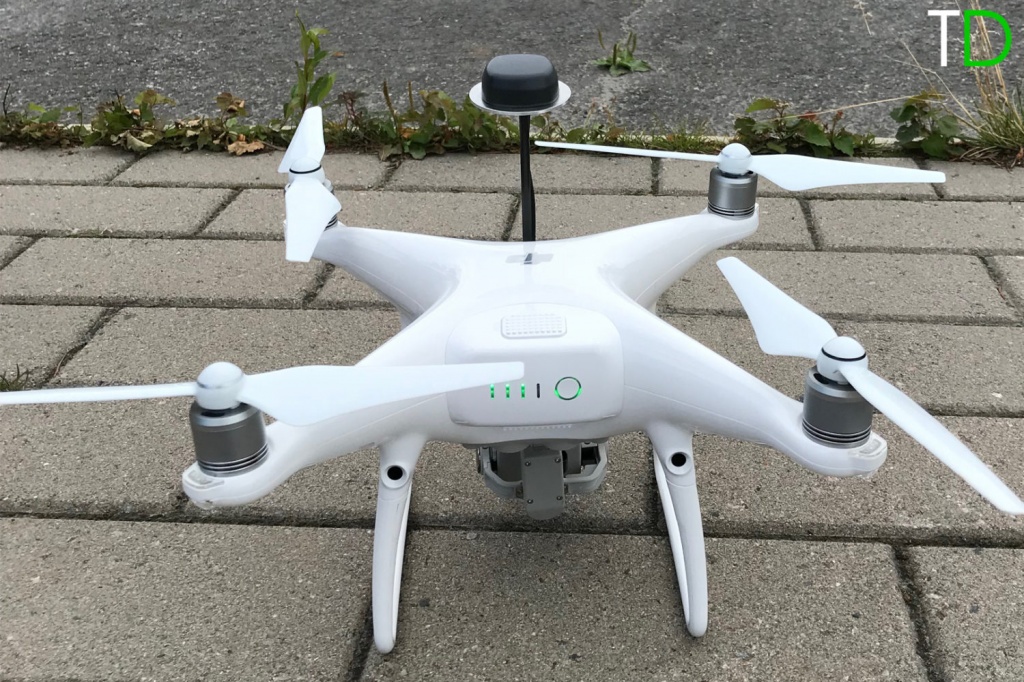
In the second stage we prepared DJI PHANTOM 4 PRO PPK for operation (Fig.2a, Fig.2b), installed a removable GNSS antenna and turned on the power of the drone. We created a new project for aerial photography in mobile applications MapPilot and Pix4D, performed the camera settings necessary to set a fixed focal length and a correct light value.
We made flights, received a set of stereo images and downloaded the necessary GNSS measurements from the drone and the base station.


On the second day, we jointly performed the entire process data processing with a lively discussion of technical and theoretical aspects.
In the beginning, using the Toposetter software, we replaced the navigation coordinates of the images, with high-precision data, calculated during the post-processing of GNSS data in RTKLIB software.
We created a new project in PHOTOSCAN software (see Fig.3, Fig.4) imported images, set the precalibrated value of the focal length of 8.82576 mm and 1 cm accuracy for images location.
Then photos alignment was performed, coordinates of the previously measured control points were imported to the project.
Finally we checked the quality of the block adjustment and build a digital terrain model.
Participants of the seminar were pleasantly surprised by the achieved accuracy of the digital model in 3 cm (see Table 1).

Table 1. Evaluation of the accuracy of building models
|
#Label |
X/Longitude | Y/Latitude | Z/Altitude | Error_(m) | X_error | Y_error |
Z_error |
|
Point 2 |
29.745413 | 62.602363 | 97.539300 | 0.032160 | 0.031041 | 0.008358 |
-0.000943 |
|
Point 3 |
29.745415 | 62.602363 | 97.519643 | 0.034508 | 0.029503 | -0.000398 |
0.017894 |
|
Point 5 |
29.745643 | 62.602864 | 98.252712 | 0.053743 | 0.031798 | 0.017201 |
-0.039765 |
|
Point 6 |
29.745645 | 62.602863 | 98.250907 | 0.043566 | 0.037336 | -0.010807 |
-0.019678 |
|
Point 9 |
29.747084 | 62.603126 | 97.648058 | 0.055341 | 0.051491 | 0.017736 |
-0.009833 |
|
Point 10 |
29.747038 | 62.603135 | 97.650754 | 0.022952 | 0.014786 | 0.016383 |
0.006304 |
During the training our colleagues received the following practical skills:
— Mission planning in MapPilot and Pix4D App and pilots skills
— Installation of a geodetic base station, determination of ground control points coordinates
— Preparation of DJI PHANTOM 4PRO PPK for work
— Data processing (data conversion, post-processing of GNSS measurements, creation of a project for photogrammetric processing in Photoscan software, camera calibration, exporting of orthomosaic and digital terrain model)
It should be noted that during this course, the ease to use and claimed technical characteristics of the DJI PHANTOM 4 PRO PPK were confirmed and we want to pay special attention to the achieved accuracy of 3D model that was 3 cm without the use of ground control points.
We thank our colleagues for their active participation in the seminar and a huge number of interesting questions and ideas.
We hope that the acquired skills will be actively used for the implementation of projects and look forward to further cooperation in the development of affordable and high-tech unmanned systems for geodesy.
The sample data for the above project is available at https://cloud.mail.ru/public/6n12/ktTYzemYc
|
Start cooperation with an individual consultation on the selection of equipment and services.
|
Order service
|


.png)


