





Knowledge base
Blog
Services
  • Aerial Photography
    • UAV Monitoring & Inspections
    • UAV Photogrammetry
  • Laser Scanning
    • Aerial Laser Scanning
    • Quarry Surveying
    • Topographical Surveying
  • Training
    • UAV Pilot Course: Photogrammetry & ALS
Company
  • Staff
  • News
  • Reviews
  • Vacancy
  • Licenses
  • Documents
  • Partners
Information
  • Requisites
Brands
Contacts
    +41 21 588 02 11
    +41 21 588 02 11 09:00-18:00 whatsapp.svg
    Sales [email protected] email.png
    Support [email protected] email.png
    Telegram Channel @topodronesa tg.svg
    Telegram Chat @topodronesagroup tg.svg
    Telegram Bot @topodronecombot tg.svg
    Facebook @topodronesa ycz1c9257s6gh7g315r8q6tob3bnddba.png
    Youtube @topodronesa youtube.png
    LinkedIn @topodrone 9ratq3v3eavnhupo1akvxp0sbx4vopj5.png
    X @topodrone twitter.png
    Instagram @topodrone tpxkj71axu6dxt423lwj5idzwcej1njx.png
    Email
    [email protected] - Sales
    [email protected] - Support
    The address
    TOPODRONE SA, Rue de la Gare 13, 1820 Montreux, Switzerland
    Working hours
    10:00-18:00
    TOPODRONE
    SPH Engineering
    3Dsurvey
    Velodyne
    DJI
    GreenValley International
    Honeywell
    Fixar
    Blue Marble Geographics
    Sony
    Agisoft
    EMLID
    Pix4D
    Autel Robotics
    SHAREUAV
    • LiDAR
      LiDAR
      • Aerial Survey LiDAR
      • SLAM Survey LiDAR
      • LiDAR Accessories
    • Bathymetry
      Bathymetry
    • Photogrammetry
      Photogrammetry
      • Mapping Drones
      • Drone Mapping Cameras
      • VTOL Mapping Cameras
    • PPK Upgrade Kits
      PPK Upgrade Kits
      • PPK for Drones
      • PPK for any UAV
    • Spectrography
      Spectrography
      • Thermal
      • Multispectral
    • UAV
      UAV
      • DJI
      • Autel Robotics
      • FIXAR
      • Innotech drone
    • Payload
      Payload
      • Aerial Survey LiDAR
      • Bathymetric Scanner
      • Photogrammetric Cameras
      • Thermal Cameras
      • Multispectral Cameras
      • Beacon
    • Software
      Software
      • TOPODRONE
      • UgCS
      • Agisoft
      • 3Dsurvey
      • LiDAR360
      • DJI
      • PIX4D
    • GNSS Equipment
      GNSS Equipment
      • EMLID
      • DJI
    TOPODRONE – LiDAR & UAV Survey
    Log in
    0 Comparison
    0 Favorites
    0 Cart
    TOPODRONE – LiDAR & UAV Survey
    Log in
    0 Comparison
    0 Favorites
    0 Cart
    TOPODRONE – LiDAR & UAV Survey
    Telephones
    +41 21 588 02 11 09:00-18:00 whatsapp.svg
    Sales [email protected] email.png
    Support [email protected] email.png
    Telegram Channel @topodronesa tg.svg
    Telegram Chat @topodronesagroup tg.svg
    Telegram Bot @topodronecombot tg.svg
    Facebook @topodronesa ycz1c9257s6gh7g315r8q6tob3bnddba.png
    Youtube @topodronesa youtube.png
    LinkedIn @topodrone 9ratq3v3eavnhupo1akvxp0sbx4vopj5.png
    X @topodrone twitter.png
    Instagram @topodrone tpxkj71axu6dxt423lwj5idzwcej1njx.png
    Email
    [email protected] - Sales
    [email protected] - Support
    The address
    TOPODRONE SA, Rue de la Gare 13, 1820 Montreux, Switzerland
    Working hours
    10:00-18:00
    0
    0
    0
    • Cabinet
    • 0 Compare
    • 0 Favorite
    • 0 Cart
    • Brands
    • Sales
    • Services
      • Services
      • Aerial Photography
        • Aerial Photography
        • UAV Monitoring & Inspections
        • UAV Photogrammetry
      • Laser Scanning
        • Laser Scanning
        • Aerial Laser Scanning
        • Quarry Surveying
        • Topographical Surveying
      • Training
        • Training
        • UAV Pilot Course: Photogrammetry & ALS
    • Company
      • Company
      • Staff
      • News
      • Reviews
      • Vacancy
      • Licenses
      • Documents
      • Partners
    • Blog
    • Information
      • Information
      • Requisites
    • Contacts
    +41 21 588 02 11 09:00-18:00
    • Telephones
    • +41 21 588 02 11 09:00-18:00
      whatsapp.svg
    • Sales [email protected]
      email.png
    • Support [email protected]
      email.png
    • Telegram Channel @topodronesa
      tg.svg
    • Telegram Chat @topodronesagroup
      tg.svg
    • Telegram Bot @topodronecombot
      tg.svg
    • Facebook @topodronesa
      ycz1c9257s6gh7g315r8q6tob3bnddba.png
    • Youtube @topodronesa
      youtube.png
    • LinkedIn @topodrone
      9ratq3v3eavnhupo1akvxp0sbx4vopj5.png
    • X @topodrone
      twitter.png
    • Instagram @topodrone
      tpxkj71axu6dxt423lwj5idzwcej1njx.png
    • [email protected] - Sales
      [email protected] - Support
    • TOPODRONE SA, Rue de la Gare 13, 1820 Montreux, Switzerland
    • 10:00-18:00
    Main
    Blog
    3D modeling of cultural heritage Chillon Castle by TOPODRONE AUTEL EVO II PRO PPK

    3D modeling of cultural heritage Chillon Castle by TOPODRONE AUTEL EVO II PRO PPK

    3D modeling of cultural heritage Chillon Castle by TOPODRONE AUTEL EVO II PRO PPK
    23 May 2022

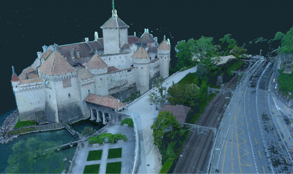
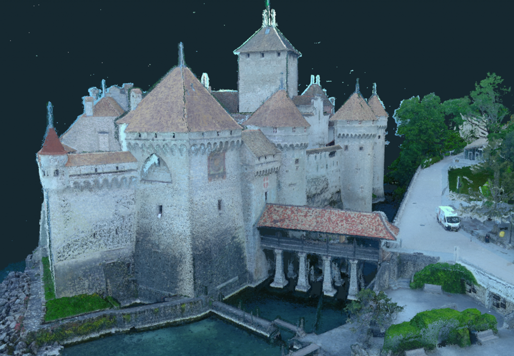
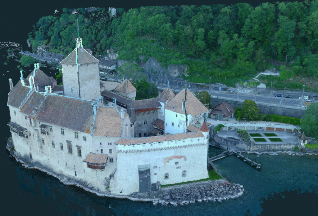
    In this article, we will discuss 3D modeling of heritage sites on the example of Chillon Castle, located in one of the most beautiful corners of the Swiss Riviera on the shores of the Geneva Lake, surrounded by the deep blue water surface on one side and the Alpine Mountain area on the other.

    Due to the special location of this castle on the coast and the impossibility to perform ground laser scanning along most of the castle walls from the lake side, we decided to use drone technology and photogrammetry to carry out 3D modeling job.

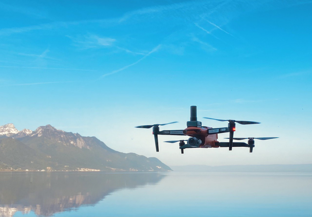
    We used the AUTEL EVO II PRO drone with additional PPK hardware on board as the main working tool for data collection.
    01.png

    Fig. 1. TOPODRONE AUTEL EVO II PRO PPK.

    You may reasonably ask why the choice was not made in favor of other types of survey drones, such as the DJI Phantom 4 RTK? In order to answer this question, you only need to study the specifications and features of this drone:

    1. Flight time. TOPODRONE AUTEL EVO II PRO PPK is able to stay in the air and perform a survey mission for 30 minutes, against 20 minutes for DJI drones. This characteristic was important for us when capturing images over water, where battery life is critical.

    2. Image quality. Based on the results of testing and visual analysis of photos, we concluded that the AUTEL EVO II PRO delivers more details and provides high sharpness of images, which subsequently affects the detail and quality of the 3D model. You may rightfully claim, well how come, but the DJI Phantom 4 RTK camera has Global Shutter and the EVO II Rolling Shutter? As you probably already know, most photogrammetric software, e.g. Agisoft Metashape, Pix4Dmapper, 3Dsurvey - provide rolling shutter distortion correction without any difficulty when using high precision photo locations, so Rolling Shutter is not a limitation for photogrammetry.

    3. RTK or PPK. The geographic location of the site resulted in the following challenges for surveying: the inability of the total station to determine control points on the walls facing the lake, the close proximity of mountains covering half of the sky, and the possible unstable operation of RTK on the drone would result in poor accuracy of the image coordinates. To solve these problems, we have installed on the AUTEL EVO II PRO a module from TOPODRONE, which is synchronized with the camera, allowing after post-processing of the GNSS measurements to identify the coordinates of the photo centers and use them for further photogrammetric processing of images. At the same time PPK equipment does not require real-time communication with the base station and provides more stable and accurate determination of image coordinates and drone movements as compared to RTK technology. We used EMLID REACH RS2 GNSS receiver as a base station.

    4. Cost of equipment. AUTEL EVO II PRO + TOPODRONE PPK kit has two/three times lower cost compared to DJI P4 RTK.

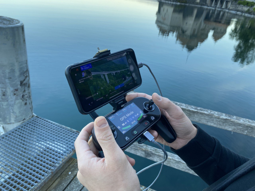
    We used the built-in AUTEL application to plan aerial survey trajectories and performed a mission with overlap of 70% and 80% at 60 meters in double grid mode, as well as oblique flight.
    02.png

    Fig. 2. Survey flight control in Autel App.

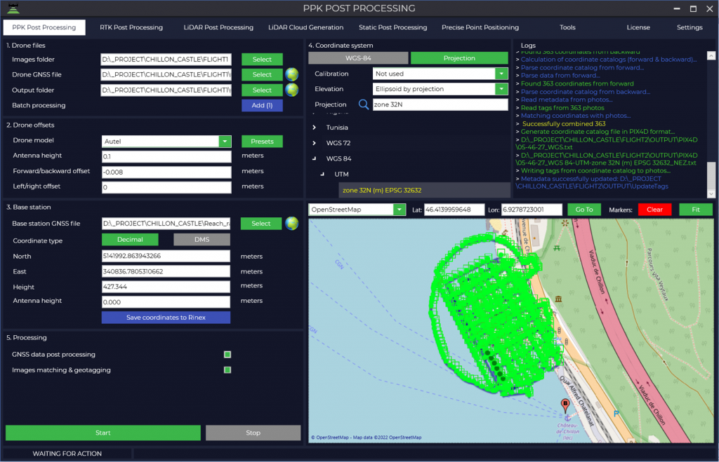
    After performing fieldwork, we loaded the images into TOPODRONE Post Processing software, calculated high-precision coordinates of the images, and recorded them in the EXIF tags of the images.
    03.png

    Fig. 3. Autel EVO II Pro post processing.

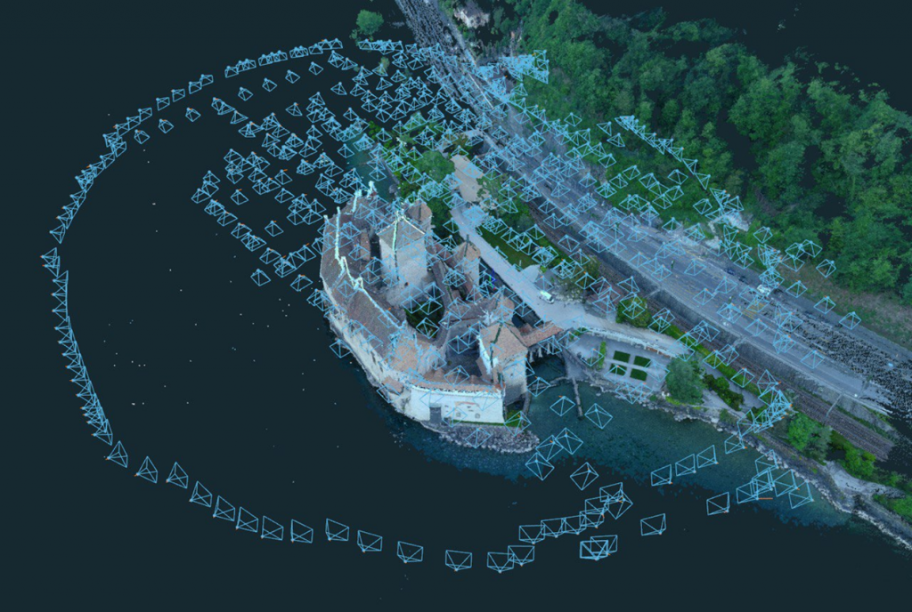
    The next step was to create a project in 3Dsurvey software, start the block alignment and generating a dense point cloud.
    04.png

    Fig. 4. Photo’s location.

    05.png

    Fig. 5. 3D model of Chillion castle.

    06.png

    Fig. 6. 3D model of Chillion castle.

    07.png

    Fig. 7. 3D model of Chillion castle.


    • Comments
    Loading comments ...
    Back to the list
    Subscribe to the newsletter of our news and stocks
    Subscribe to
    Connect with us
    +41 21 588 02 11
    +41 21 588 02 11 09:00-18:00 whatsapp.svg
    Sales [email protected] email.png
    Support [email protected] email.png
    Telegram Channel @topodronesa tg.svg
    Telegram Chat @topodronesagroup tg.svg
    Telegram Bot @topodronecombot tg.svg
    Facebook @topodronesa ycz1c9257s6gh7g315r8q6tob3bnddba.png
    Youtube @topodronesa youtube.png
    LinkedIn @topodrone 9ratq3v3eavnhupo1akvxp0sbx4vopj5.png
    X @topodrone twitter.png
    Instagram @topodrone tpxkj71axu6dxt423lwj5idzwcej1njx.png
    Email
    [email protected] - Sales
    [email protected] - Support
    The address
    TOPODRONE SA, Rue de la Gare 13, 1820 Montreux, Switzerland
    Working hours
    10:00-18:00
    [email protected] - Sales
    [email protected] - Support
    TOPODRONE SA, Rue de la Gare 13, 1820 Montreux, Switzerland
    Products
    Sales
    Brands
    Services
    Applications
    Company
    Staff
    News
    Reviews
    Vacancy
    Licenses
    Documents
    Partners
    Information
    Requisites
    Help
    Payment
    Delivery
    Warranty
    FAQ
    © 2026 TOPODRONE SA
    Privacy Policy
    Main page Product 0 Comparison Contacts Blog Applications