


.png)


3D OVERVIEW MODEL OF DADIANI PALACE: LANDSCAPE PLANNING AND REDEVELOPMENT

Contents
- 3D Overview Model of the Dadiani Palace
- Landscape Planning and Redevelopment
- The Historic Dadiani Palace
- Photogrammetry and BIM for Modern Landscape Design
- The Role of an Overview Model in Digital Landscape Design
- Potential for the Development of the Palace Grounds
- Methodology for Surveying the Dadiani Palace Grounds Using PPK
- Data Processing and Final Outputs
- Conclusion

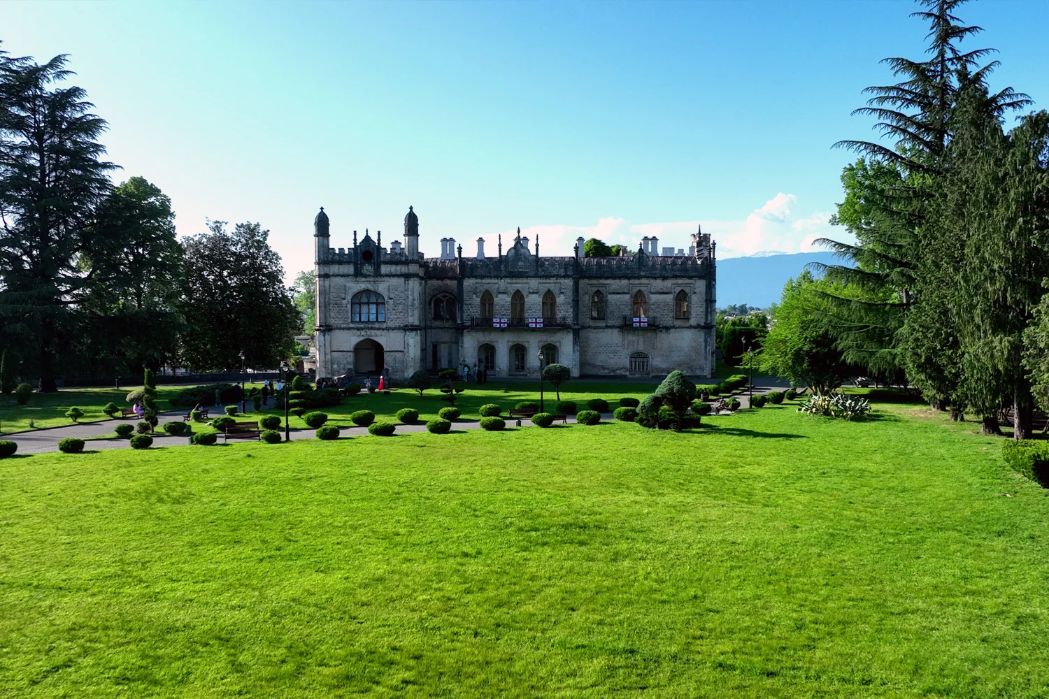
Image 1. The Dadiani Palace in Zugdidi
The Historic Dadiani Palace
The Dadiani Palace in Zugdidi is an outstanding architectural monument of the 19th century, constructed in a neo-Gothic style with elements of Georgian, Russian, Islamic, and Tudor architecture, designed by the English architect Edwin Rice. The complex functions as a museum with a collection of approximately 41,000 exhibits, including artefacts of the Dadiani family and relics related to Napoleon Bonaparte.
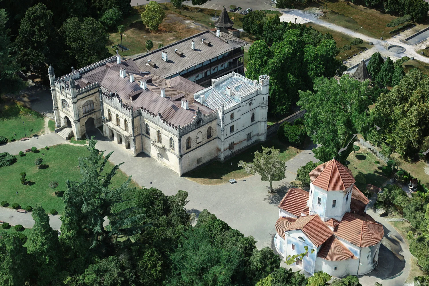
The TOPODRONE team conducted an initial overview photogrammetric survey of the Dadiani Palace grounds and the adjacent botanical garden using the industrial DJI Matrice 350 drone system equipped with a TOPODRONE P24 camera and a PPK module.
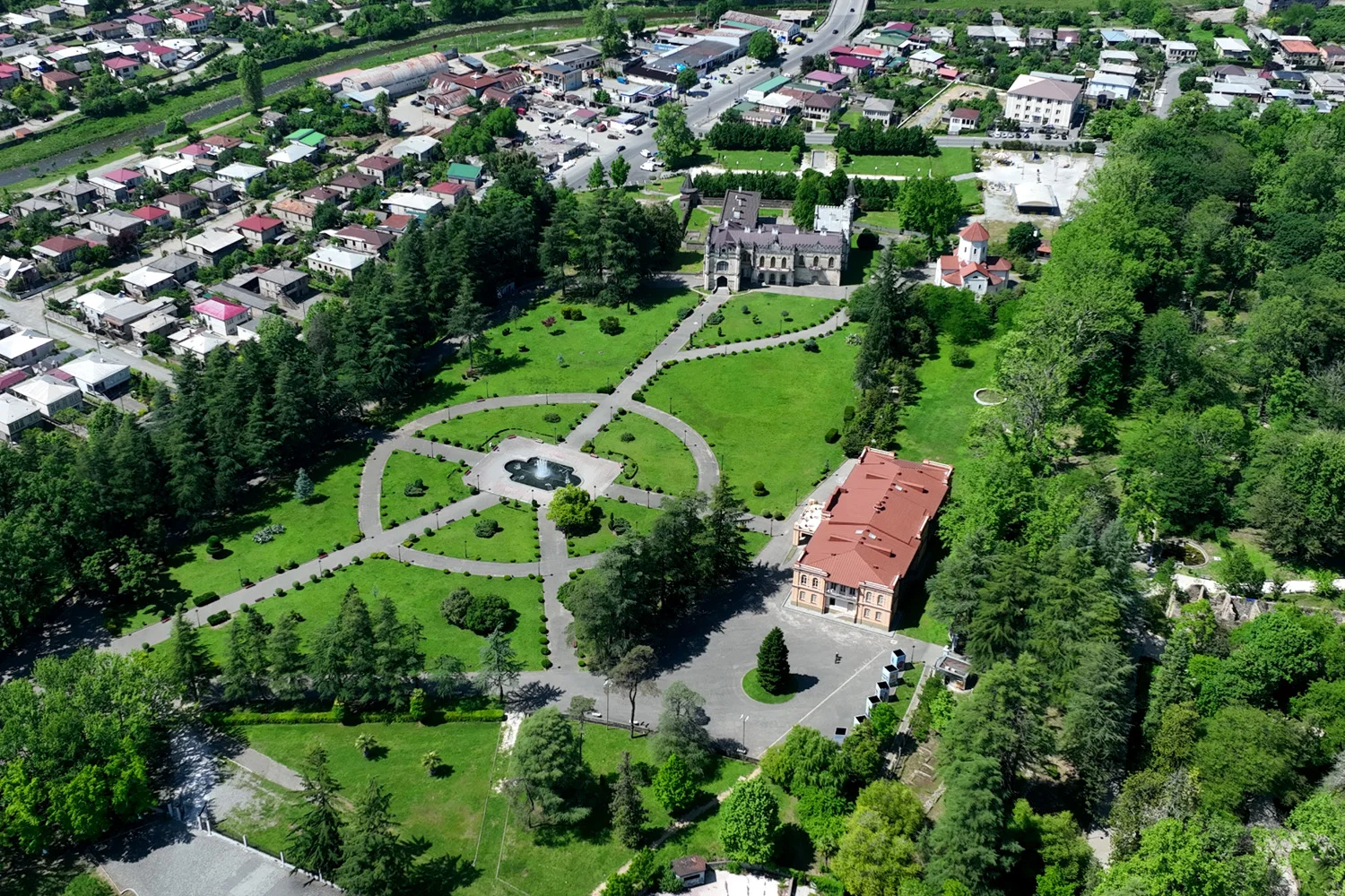
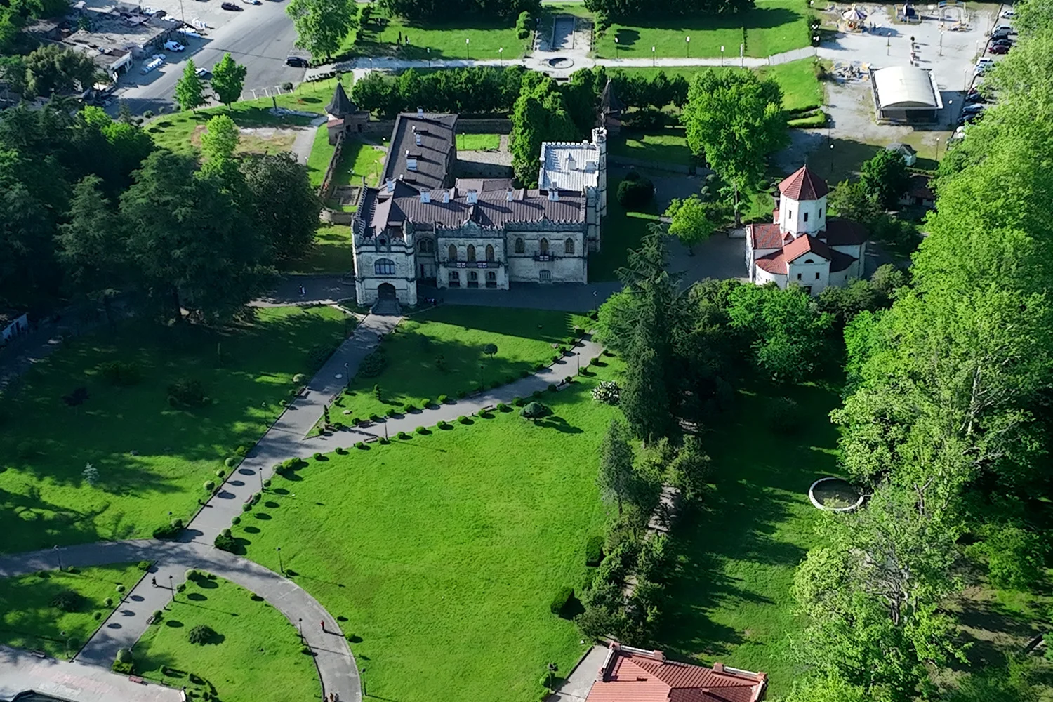
Images 2-4. Drone Survey of the Dadiani Palace
Photogrammetry and BIM for Modern Landscape Design
Photogrammetry is a powerful tool for contemporary landscape designers working with historic or complex sites. The technology allows the creation of accurate, photorealistic 3D models of buildings and terrain based on a series of standard photographs.
Using a drone and photogrammetry, it is possible to obtain a high-precision Digital Terrain Model (DTM) or Digital Surface Model (DSM). These data are used for various practical tasks. For example, a DTM allows assessment of surface slope, drainage direction, and the design of an effective drainage system. Working with digital twins of planned areas enables easier and more precise planning of terraces, retaining walls, stairways, as well as calculating the volume of soil to be removed or added for constructing rock gardens or leveling surfaces.
The photogrammetric data obtained provide a foundation not only for “modelling” the palace and garden, but for an entire concept of managing data about the palace complex throughout its lifecycle. When using BIM (Building Information Modelling), a modern approach is applied, creating an intelligent 3D model containing all information about the site.
Thus, BIM technology in a broad sense is a comprehensive process of forming and managing an informational model of an object in a digital environment. It reflects all aspects of the project, from terrain and engineering networks to landscaping elements, greenery, and public zones.

Image 5. General view of the overview 3D point cloud model of the Dadiani Palace
In landscape design, BIM becomes a tool for:
- Accurate analysis of the site (slopes, drainage, insolation);
- Planning the placement of pathways, green areas, and small architectural forms;
- Integrating information on plant care, irrigation, lighting, and infrastructure;
- Monitoring the project lifecycle — from concept to operation.

Image 6. Lifecycle of BIM in Landscape Design.
Therefore, BIM technology helps “construct” not only buildings, but harmonious and sustainable landscapes, with projects first calculated digitally and then implemented on-site.
The Role of an Overview Model in Digital Landscape Design
The overview 3D model of the Dadiani Palace grounds serves as an initial digital archive, recording the topographical and spatial characteristics of the site. The model allows preliminary terrain analysis, identification of potential areas for change, and minimisation of errors during detailed surveying.
Photogrammetry using the DJI Matrice 350 + P24 + PPK system enables the creation of point clouds, an orthophotoplan, and a basic textured terrain model. The survey covers the entire area, including hard-to-reach sections of the botanical garden, providing a complete spatial representation without the constant presence of specialists.
The overview model is integrated with other geospatial data sources, such as ground measurements or aerial laser scanning. Combining different sources forms a single digital framework of the site, ready for integration into GeoBIM. Accuracy verification using control points ensures reliability and correctness of subsequent design decisions.
GeoBIM is an extension of classic BIM technology to geospatial data. GeoBIM allows integration of digital terrain models, engineering networks, infrastructure, landscape objects, and vegetation into a single informational environment, supporting comprehensive site management, analysis, and design at all stages of the project lifecycle.
The overview 3D model serves as a working tool for planning the development of the landscape zone and lays the foundation for the long-term preservation of the Dadiani Palace’s historical and cultural heritage.
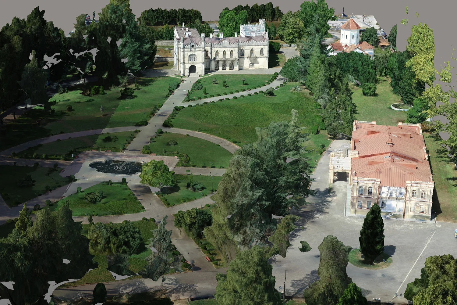
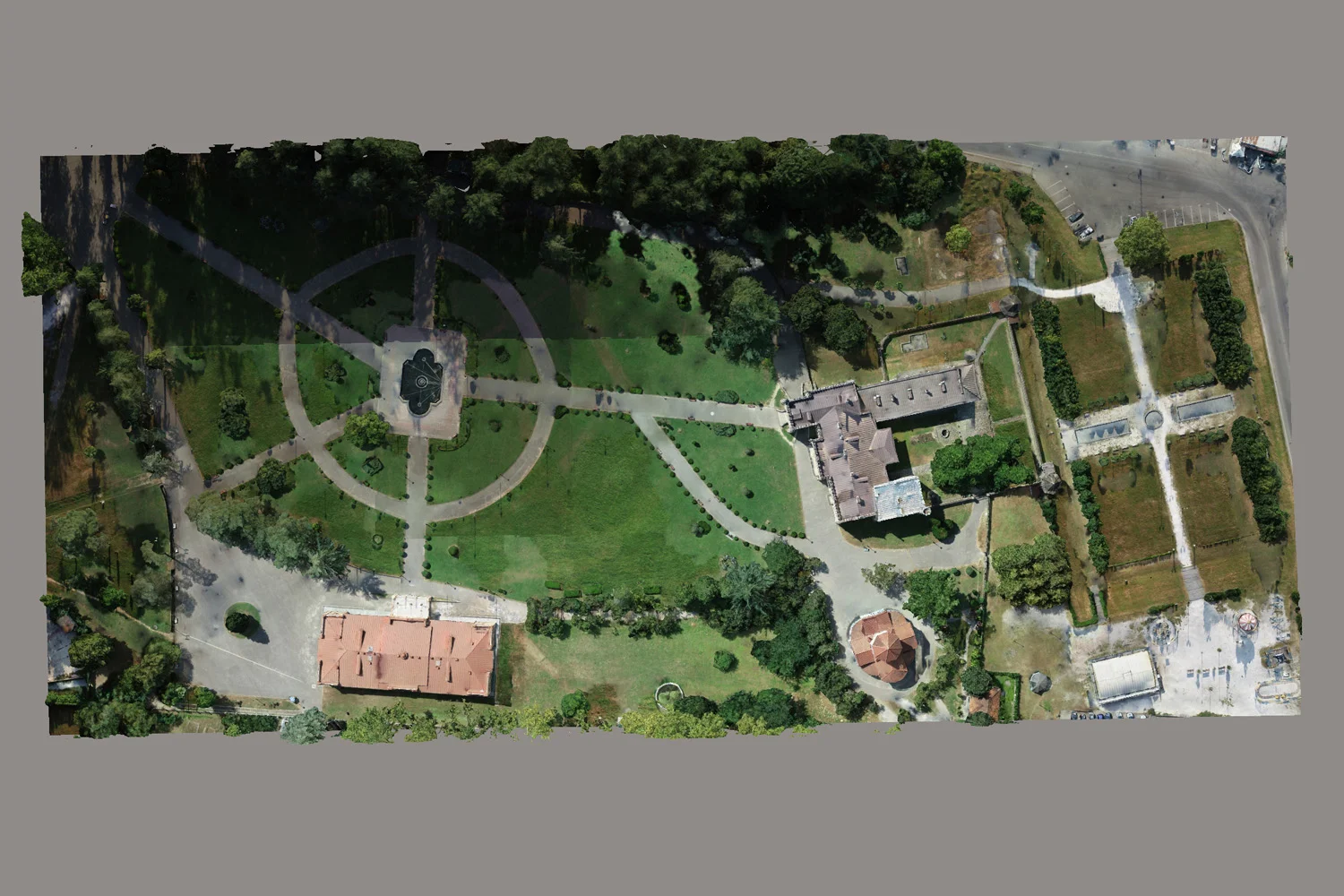
Images 7-9. Overview 3D model of the Dadiani Palace based on photogrammetry
Potential for the Development of the Palace Grounds
The digital 3D model of the Dadiani Palace grounds provides significant opportunities for the long-term development and management of the botanical garden. It allows:
- Integration of data into landscape BIM/H-BIM — combining geometric terrain models with information about plants, irrigation systems, pathways, lighting, and small architectural forms, creating a single digital object for management;
- Support for educational and tourism projects — accurate models can be used to create virtual tours, interactive excursions, and visualisations of future changes, making the garden accessible to a wider audience;
- Monitoring changes over time — repeated photogrammetric surveys allow tracking of tree growth, lawn and pond conditions, and assessment of the effects of seasonal changes and maintenance activities;
- Developing a sustainable development strategy — the digital model helps make decisions that preserve the historical and cultural context, optimise plant care, plan new elements, and improve garden infrastructure.
Thus, the 3D model becomes not only a design tool but also a means of systematic management and long-term preservation of the historical and landscape heritage of the Dadiani Palace.
Methodology for Surveying the Dadiani Palace Grounds Using PPK
The photogrammetric survey of the Dadiani Palace grounds and adjacent botanical garden was conducted under conditions limiting the use of ground-based equipment. The industrial drone system used was:
UAV platform: DJI Matrice 350 RTK
Photogrammetric camera: TOPODRONE P24
PPK module: TOPODRONE (L1/L2 GNSS)
Key features of the survey:
- Use of PPK with virtual RINEX via CORS to enhance coordinate accuracy;
- Georeferencing of images with 3–5 cm accuracy, ensuring high metric reliability of the model;
- Multi-level flight scheme:
- Vertical (nadir) images for precise capture of horizontal surfaces — pathways, flower beds, and squares;
- Oblique shots from two altitudes (~40 m and above) for detailed survey of trees, shrubs, and architectural elements of garden compositions.

Image 10. Industrial UAV Photogrammetry System DJI Matrice 350 + TOPODRONE P24 Camera + PPK
This system allows the creation of three-dimensional point clouds (DTM, DSM) of the entire palace and garden, forming the basis for terrain analysis, landscape planning, and integration into digital management systems.
Data Processing and Final Outputs
The photogrammetric data of the Dadiani Palace grounds and botanical garden were processed in Agisoft Metashape software, one of the leading solutions for industrial photogrammetry.
The outputs include:
- Textured 3D mesh — a photorealistic model of terrain, pathways, flower beds, ponds, and greenery;
- Point cloud — high-precision spatial information for analysis of terrain, trees, and architectural elements;
- Metric-accurate model — point cloud ready for integration into digital landscape management systems and landscape BIM.
Video 1. Overview 3D Model of the Dadiani Palace in Zugdidi
Conclusion
The overview model serves as a working foundation for further design. Based on it, new pathways, recreation areas, placement of small architectural forms, irrigation, and lighting systems can be planned. For detailed analysis of specific garden areas, such as microclimatic zones or rare plants, additional high-resolution surveys (GSD < 5 mm/pixel) may be required.
Even at the overview level, the 3D model provides a complete spatial understanding of the Dadiani Palace grounds, allowing specialists to optimize landscape design and make informed decisions regarding the development and maintenance of the historical and cultural garden.

Image11.Dadiani Palace in Zugdidi, Georgia