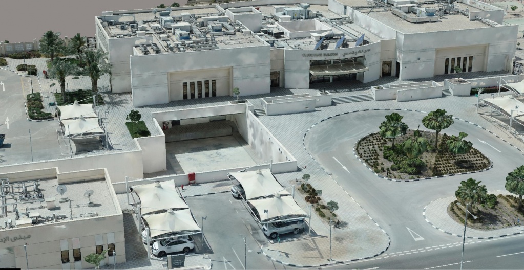
3D modelling of urban areas with TOPODRONE equipment

Our customers are very interesred in 3D modeling of urban areas, creating as-built models and collecting data for BIM models.
This article is a logical foollow-up to our article, dated the February 2018, where we have shown how the use of a survey drone TOPODRONE DJI Phantom 4 Pro v2.0 L1/L2 RTK/PPK can simplify the process of detailed 3D-modelling of a complex building, in particular, the St. Seraphim of Sarov Church.

Img. 1. 3D model of the St. Seraphim of Sarov Church.
The detailed 3D models are used for designing buildings and constructions, road infrastructure building control, geological modelling of open-pit sides etc.

Img. 2. 3D model of a newly built road interchange.

Img. 3. 3D model of technologically sophisticated objects.

Img. 4. 3D model of a hotel, made for the further reconstruction.

Img. 5. 3D model of a hotel made for site improvements planning.

Img. 6. 3D model of a building with an underground parking entrance.
Aerial survey planning
The basis for a detailed modelling is a properly done aerial survey, whereas the use of TOPODRONE survey drones makes it much easier and faster to create precise and detailed 3D models.
It is reasonable to combine different survey types:
- surveying at nadir, with double grid at an altitude of 40-60 meters
- surveying at 30-45 deg. camera bias, with double grid and at an altitude of 40-60 meters
- oblique and facet surveying
- land surveying
The quality of the 3D model, flight safety and the integrity of the equipment highly depend on mission planning, so it is very important to do this process properly for such tasks.
It is important to provide enough overlapping and properly represent the architectural features of the building without making unnecessary photos. Avoid taking photos that capture too much sky or moving objects.
You will need to have good piloting skills and manually control the drone or use a professional mission planning software while doing complicated flight missions.
We believe that the UgCS software is the best option for mission planning. Below there is an example of a building survey that includes nadir, oblique and facet aerial survey.

Img. 7. Planning missions for nadir, oblique and facet aerial survey.
We shall note that taking photos from the ground is essential if one needs to display all building and construction elements, that can not be seen from the altitude of the drone. For example, objects below the canopies, trees, lower floors of buildings etc.
TOPODRONE team has designed an equipment kit (the link to the product is on the website), that makes taking photos from the ground easy and simple. It includes a 2-axis steadicam, L1/L2 GNSS receiver and a professional camera. This kit can be carried in hands or mounted on a vehicle roof, thus the productivity sufficiently increases.
.jpg)
Img. 8. TOPODRONE Handheld Survey Kit L1/L2.
Taking photos from the ground with TOPODRONE Handheld Survey Kit L1/L2 RTK/PPK has been successfully tested in a project of more than 7.5 km2 city area 3D modelling.

Img. 9. Installation of the TOPODRONE Handheld Survey Kit L1/L2 on a vehicle.
The use of L1/L2 GNSS receiver, paired with the camera and saving precise photo coordinates, has greatly facilitated the integration with the aerial data and data processing.
The TOPOSETTER 2.0 PRO software proved to be very useful for the data and image preprocessing. It allows to do GNSS data postprocessing, processing batch data from multiple flights with single base and writing precise coordinates into image exif tags.
The images below present an example of land and aerial data postprocessing results.

Img. 10. The results of land and aerial data postprocessing.
The TOPODRONE Handheld Survey Kit L1/L2 can be used with the camera from TOPODRONE DJI Matrice 200 V2 L1/L2/L5 RTK/PPK + 42Mp kit.
Below we present 3D models that have been made with the use of land survey data. Note the precision and the level of details below the canopies and awnings. This level of quality can not be achieved using only a drone for surveying.

Img. 11. 3D model of an object, based on the photos taken from the ground.

Img. 12. 3D model of an object, based on the photos taken from the ground.

Img. 13. 3D model of an object, based on photos taken from the ground.

Img. 14. 3D model of an object, based on the photos taken from the ground.

Img. 15. 3D model of an object, based on the photos taken from the ground.

Img. 16. 3D model of an object, based on the photos taken from air and from ground.

Img. 17. 3D model of an object, based on the photos taken from air and from ground.

Img. 18. 3D model of an object, based on the photos taken from air and from ground.

Img. 19. 3D model of an object, based on the photos taken from air and from ground.

Img. 20. 3D model of an object, based on the photos taken from air and from ground.
|
Start cooperation with an individual consultation on the selection of equipment and services.
|
Order service
|


.png)


